photographers Geoff Fenton, Janet Fenton
The geological records of most countries contain unconformities – sections where a significant amount of rock is missing, usually due to erosion, and there is a discordant contact between the older and younger rock units. Some classic examples include the “Great Unconformity” in the Grand Canyon of Colorado, US, where Cambrian sandstone overlies deformed Precambrian rocks with a missing time gap of about 500 million years. Another is the Siccar Point unconformity of James Hutton (the Scottish “father of modern geology”, 1726-1797) between Devonian old red sandstone and Silurian sandstone and shale, with 80 million years missing, on the east coast of Scotland.
Such regional unconformities typically happen when two continents or continental fragments, collide – a remarkably common occurrence on our mobile Earth, we now realise. The double thickness of rocks is folded and compressed and pushed up into mountains, then eroded over millions of years down to sea level again. Younger sediments, in horizontal layers, are then deposited over the top of the old folded rocks, giving the angular discordance we know as an unconformity.
Tasmania has one such “classical” unconformity within its geological record, between the horizontally layered Permian mudstone sequence – part of what I’ve termed the “middle-aged rocks”, which also include the Triassic sandstones and Jurassic dolerite – and the “old folded rocks”. These old folded rocks range in age from early Devonian (about 400 million years) to Precambrian (about 1,400 million years), and vary from place to place. For example, they include the Cambrian Mt Read volcanics and the conglomerate ranges of the West Coast, the cave-bearing Ordovician limestones of the west and north, and the thinly-layered slates and sandstones of the north-east and east. But all were folded in a great collision-mountain building tectonic event in the middle of the Devonian period, about 380 million years ago.
Tasmania was situated on the east coast of Gondwana at the time. Geologists know this event as the “Tabberabberan Orogeny”, named for a small place (Tabberabbera) in eastern Victoria. The exact nature of the event is still uncertain, but may have involved a continental collision or an acceleration of convergence at a subduction zone. Granites were intruded into the folded and deformed rocks beneath the mountains, as a consequence of the heating and melting which occurs at such depths, and the deep erosion which occurred over the ensuing 50 million years or so saw some of these granite bodies exposed at the surface.

The Devonian mountains were steadily eroded away, as mountains are in geological history. Even an erosion rate of 1mm per year gives 10m in 10,000 years and 1km in 1 million years. (The Himalayan mountains are probably eroding at a faster rate than this, but are not being much reduced because they are still being pushed up, as India continues to bulldoze northwards at about 7cm per year). Eventually, after an Ice Age and some additional erosion by glaciers across Tasmania in the Carboniferous (about 300 million years ago), much of the Tasmanian landscape was reduced to sea level, and marine mudstones were deposited across the erosion surface of the old rocks. In some places, particularly in hollows in the surface, rubbly conglomerates were deposited as screes or river-washed gravels. These are referred to as “basal conglomerates”, and are common along unconformity surfaces.
Tasmania’s great unconformity is present across about two-thirds of the state, wherever the Permian mudstones are found resting on older rocks. It is seldom easy to see it, however, because of cover by dolerite scree or other superficial material. I have seen exposures at Mt Sedgwick and Mt Read, and particularly at Cradle Mountain, where the horizontal benches of Permian conglomerate around the west flank and along to Fury Creek can be seen to overlie the upturned layers of old Precambrian quartzite. An excellent and unusual exposure is present on the east coast of Forestier Peninsula near Cape Surville, where granite of the “old folded rocks” is overlain by horizontal Permian beds, and both have been intruded by a large, dark-coloured dike of the later Jurassic dolerite.

But by far the most dramatic and spectacular exposures of the unconformity are along the eastern coast of the northern part of Maria Island. Maria is a microcosm of eastern Tasmanian geology, with a basement of folded rocks (slates and sandstones of Silurian to Devonian age) and large intrusions of granite, overlain by Permian mudstones (with some included limestone units) and Triassic sandstones, capped by Jurassic dolerite along the main range. A major north-south rift fault, probably continuous with that which bisects Schouten Island to the north, transects the island and brings the dolerite down to sea level on the west coast.
The great unconformity is the surface between the folded rocks and granite below and the horizontal Permian beds above, and this surface is clearly visible at sea level along Maria’s east coast. I first saw this unconformity exposure on a boat trip, on which I was a geological guide, in 2003, and was so impressed I couldn’t help raving about it to my fellow, somewhat bemused, passengers. My single photo of it taken from the boat has been used multiple times. But some much better images, of a longer section of the coast, have kindly been passed on to me recently by friends Geoff and Janet Fenton, and I share some of them with you in this post.
As well as the unconformity, the photographs show some highly unusual developments of limestone karst features on the Permian cliffs, seemingly related to rain water acting on an exposed limestone unit.
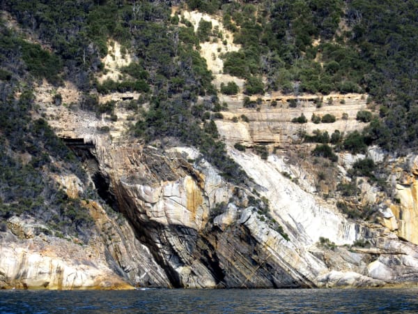
Image 1: This general view shows the old folded rocks at sea level, sharply overlain by the grey horizontal Permian mudstones, some stalactite-like material hanging down from a limestone unit just above, passing up into vegetated cliffs of Permian, and the cap of Jurassic dolerite forming the peak. The landslide may have developed on a fault zone, since the mudstones seem to be displaced down to sea level to the left of this.
Image 2: A close-up of the unconformity shows the vertically-dipping folded rocks overlain by a superb example of a basal conglomerate filling a shallow depression in the unconformity surface. Some rounding of the pebbles suggests this may be a near-source river deposit.
Image 3: The tight folding of the slates and sandstones, resembling a ruckled carpet, and the truncation of the folds at the unconformity, are superbly shown here.
Image 4: Here, a series of granite dikes can be seen intruding and cutting across the slates, and both are truncated by the unconformity. The intrusion of the granite into the folded rocks was the last thing to happen as part of the orogeny, in the Devonian. The stages involved were: (i) folding of the slates and sandstones; (ii) intrusion of the granite into the slates at about 360 million years; (iii) deep erosion of the mountains down to the level of the granites; (iv) deposition of the Permian mudstones at about 280 million years. The time gap represented by the unconformity is about 80 million years.
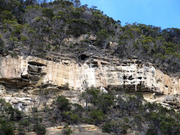
Image 5: General view of the Permian cliffs showing the pale grey limestone unit with its small cavernous holes and numerous surface stalactites.
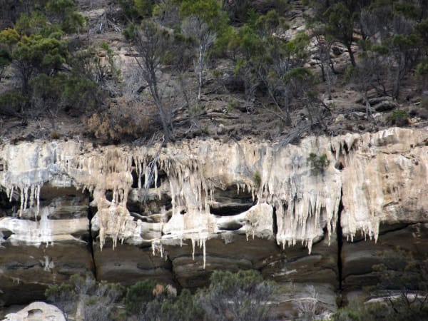
Image 6: Close-up view of the limestone unit with surface stalactites. This material, and the small caves in the limestone, must have been developed by the action of rain water running down the slope during storms and perhaps sea fogs. There are no creeks as such on these sub-vertical slopes. Karst experts Chris Sharples and Grant Dixon report that similar phenomena, although not so well developed, are present along some of the sea-facing Permian cliffs on Forestier Peninsula.
So the far coast of Maria Island gives us a grand view of perhaps the most significant tectonic event in Tasmania’s long and varied geological history. From these superb exposures we can interpret a continental collision involving mountain building, folding and granite intrusion, followed by deep erosion over some 80 million years to wear down these mountains, then deposition of younger horizontal beds across the eroded surface to produce our great unconformity. Geology writ large!
Keith Corbett is a Tasmanian-born geologist who has spent most of his life working in the state’s mountains. This has included a PhD study of the Denison Range in the South-West, and a masters study of the Mt Lyell Mine area. His pleasures since retiring include showing people interesting geological places, and working with others to develop walking tracks around Queenstown.