Queenstown is my favourite town. I first went there in about 1960, as a geology student, to look at some of the geology and mines. My future wife, Sib, was also a student on that trip, and was refused permission to go underground at Mt Lyell Mine – having women underground was considered bad luck! Thankfully, that’s changed, and female geologists, as well as engineers, and even truck drivers, are common in mines these days.
I have worked around Queenstown, for the government’s geological survey and as a consultant geologist, for many years from the 1970s to the present day, climbing all the hills and mountains, and bashing through the valleys and down the creeks and gorges. That’s what field geologists do. And I am still captivated by the amazing geology.
I did a master’s degree in science on the Mt Lyell Mine area in the late 1990s, involving a detailed mapping survey of the whole mine Lease for the first time. So I know nearly every outcrop across those famous bare hills and the surrounding mountains.

It's a stark, challenging, terrible, beautiful, fascinating landscape, unlike any other that I know. Some people are repelled by the bareness of the hills and the state of the local streams, the obvious impacts of man’s activities, but others see beauty in the rawness and in the variety of colours and textures. And in the rocks themselves.
A thriving, and growing, group of artists is now based in Queenstown, and the Unconformity Festival, held every two years and featuring quirky and unique artistic events and displays, has become extremely popular. (The Unconformity name derives from a geological outcrop at Mt Lyell known to geologists as the Haulage Unconformity). So the town is slowly but steadily changing its character from being a basic mining town, centred around a single large company, to something else, in which art and tourism are increasingly important. But it’s a slow, painful and difficult process. The mine has been closed now for six years, since three miners were killed in accidents in 2014. There have been murmurs from the Indian owners about re-opening, but the mine was recently put up for sale.
Queenstown is a place where mining, and its worst environmental impacts, comes hard up against the power of nature, which can revegetate and cover old mining sites in just a few years in the extreme wet climate. The Mt Lyell Mine, developed in the 1890s in the middle of a wilderness, was considered one of the industrial wonders of the world for many decades. People came from all over the world to marvel at this great complex, with smelter chimneys belching smoke out of the rainforest, a great open pit at the Iron Blow, the bustling town and railways. And over its 120-year life, the mine produced more than 1.5 million tonnes of copper, worth about $10 billion at today’s prices, plus 50 tonnes of gold, worth about $3 billion, and 1,500 tonnes of silver, worth more than $100 million.
Its contribution to the Tasmania’s economy, and to the west coast and Queenstown, has been enormous.

. . .
It has come, however, at a big, and ongoing, environmental cost. The bare hills are slowly revegetating, although it is unlikely that the original rainforest will return because of the soil loss. Sadly, it’s exotic Pinus radiata, a “weed” species seeding out from some old plantations, is coming to dominate the slopes, along with some hardy acacias. And it was my pleasure recently, with a small group of friends, to re-plant some young King Billy pines (with the mine’s approval) at a carefully selected site in the hills, to perhaps begin the process of bringing back this iconic species to where it once flourished all around the mine area. Remnant stumps and stags of King Billies still stand as stark reminders of a previous time.
But it is the state of the Queen River and, to a slightly lesser extent, the King River, which is of most concern. The colour of the Queen River has changed from a soupy grey, when the pyrite-rich mine tailings were still being poured into it (a practice which began in 1922), in the early 1990s, to a bright orange-brown, since the tailings were piped to a proper tailings dam when the new company took over in 1995. The old iron-rich tailings spread along the banks of the rivers all the way to Macquarie Harbour are now oxidizing to a rusty red colour, and potent metal- and acid-rich water is still pouring into the river from the creek which drains all the mine workings and the huge old mine dumps at Mt Lyell. It does not seem possible to prevent this.

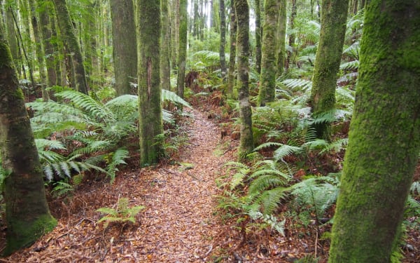
The head-on conflict between the mining impact, exemplified by the orange-coloured Queen River, and the powerful natural forces of the west finds a dramatic expression where the Queen River meets the dark waters of the King River south of Queenstown. This meeting place is known to locals as the Confluence, and is accessible to walkers in an easy 20 minutes on what is known as the Confluence Track. This track was established by Hydro Tasmania to access a gauging station on the King, and has been kept open by locals. The track passes through a superb stretch of rainforest on a terrace about 30 metres above the rivers, before dropping down some hand-made steps to a lovely open viewing space where the rivers meet. Ancient myrtles, Huon pines and leatherwoods frame the view of the orange water swirling and mixing with the powerful dark flow of the King before being carried down the gorge.
Most of the King water comes through the John Butters power station just upstream, fed from the large hydro catchment of Lake Burbury further upstream, but the water is essentially unpolluted and retains the dark tea colour so typical of western streams. The stark colour contrast was described by one onlooker as, “Fanta meets Coke.”
A superb aerial image of the Confluence, referred to as The Living Unconformity, was used as the poster image for the 2018 Unconformity Festival. I was able to bring a number of groups of 30 or so people in to see the Confluence, and to explain something of its significance, as part of this Festival.
In addition to the meeting of the rivers, and the unconformity between mining and the environment which this exemplifies, there are two other stories to be told along the track.
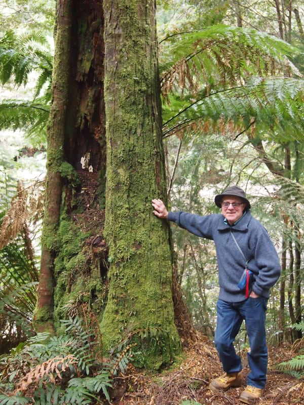
One story concerns the forest itself, which is remarkably even-aged and lacks the normal old senescent myrtles so typical of old-growth rainforests. The reason is that this forest, and indeed much of the forest across southern Tasmania, has regrown after nearly all was destroyed by the huge bushfire of 1934.
A remarkable first-hand account of this fire near Queenstown is given by a young fellow called Wal Stubbings, who walked from Strahan to Queenstown along the Abt railway line with his two brothers and friend Jack Morrison in early 1934. They wanted to compete in a chopping carnival at Queenstown the next day, and the train was cancelled because of the fires. Wal’s account, in his and Lesley Synge’s biography Wharfie (Zing Stories, 2017, p42) reads, “We set out on Friday afternoon with our competition axes on our shoulders and the bushfires all around us. Bang! Bang! came the sound of the trees exploding. ‘The myrtles are going off like cannons!’ Ken exclaimed.”
The boys made it into Queenstown at midnight and competed next day, when Jack Morrison came second to the world champion. A few of the original old myrtle survived the fire, and can be seen along the banks of the King River, one with a huge fire scar to mark its close shave.
A second story concerns the origin of the flat terrace between the rivers, which has a cover of about five metres or so of roundstone gravels above the bedrock sandstone. These are fluvioglacial gravels, deposited during the early part of the Pleistocene ice age, about one million years ago. At this time, a glacier filled much of the Queen River valley, reaching to about where Bradshaw’s sawmill now stands, and as it melted, huge quantities of gravel were washed downstream by the active meltwaters. Another glacier occupied the King Gorge at this time, melting and depositing till just upstream (including dolerite derived from the Eldon Range) and meltwater gravels downstream around the confluence area. Gravels choked the valleys, but over time the rivers have cut down through them into the bedrock, leaving gravel-covered terraces here and there to mark this period when ice ruled the landscape.
So the rivers at Queenstown tell a story of great natural events, and of a period when man had the greatest impact, and now of a slow healing process that will take many decades.
But mother nature has plenty of time.
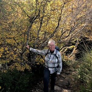
Keith Corbett is a Tasmanian-born geologist who has spent most of his life working in the state’s mountains. This has included a PhD study of the Denison Range in the South-West, and a masters study of the Mt Lyell Mine area. His pleasures since retiring include showing people interesting geological places, and working with others to develop walking tracks around Queenstown.