


photographers ROB SHAW and CRAIG SEARLE
Being widely promoted overseas (Bass Strait as well as assorted oceans) means the Overland Track tends to be frequented by so many mainland and international travellers that it sometimes resembles a major airport more than a wilderness hike.
However, while Tasmania is increasingly astute at selling its most famous multi-day excursions, it is also adept at keeping quiet about short-cuts which can make them more accessible.
The Arm River Track is one such example and, as a result, those using it are almost exclusively Tasmanian. It enables single-day access into the heart of the Overland Track, and is one of the crown jewels of Tasmanian bushwalking routes.
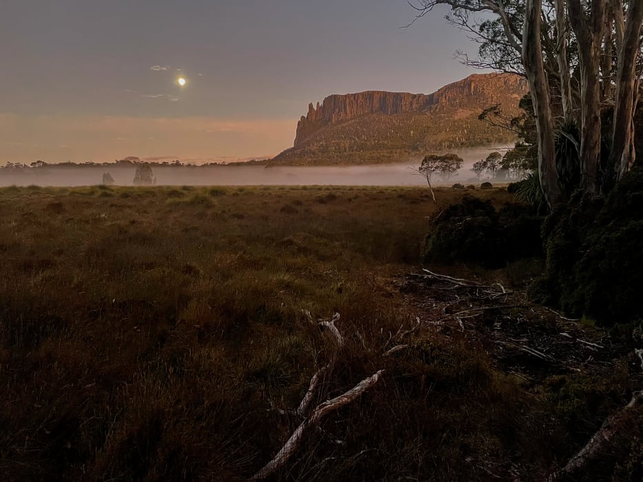
In four-to-five hours (three if you're fit and don't dawdle taking photographs), you can be at the "Pelion Palace", the central hut of the state's iconic week-long Overland Track hike. The Palace is so nicknamed because of its size and guest turnover. This impressive building opens the doors to several Abels, that collection of 158 Tasmanian mountains above 1,100 metres (each requiring a drop of at least 150m on all sides). From Pelion Hut, four Abels are eminently achievable, including the highest performer in the class. A fifth, Mount Pelion West, dominates the horizon but is to be treated with far more respect and planning.
My memories of the Arm River Track from more than a decade ago are not fond ones. From the car park at the end of Maggs Road off Lake Rowallan, the track soon veered upwards, then became steeper and, just when you were questioning your life choices, kicked up another few degrees. Since then, Parks and Wildlife have improved it considerably, introducing a gentle zig-zag track of 33 hairpin corners that ascend gradually rather than attempting to tackle the gradient head-on. What was once a nightmare is now a dream; still hard work but achievable and even enjoyable with occasional detours to refreshing waterfalls.
Attempts to clarify how much the project cost took six months before P&W said it would be "difficult to attribute a dollar figure" but confirmed it included federal and state allocations. It also involved installation of several kilometres of boardwalk, a new bridge and track hardening on Mount Oakleigh and was carried out to reduce environmental impact and improve the visitor experience after an increase in use had been observed.
Mount Pillinger's primary reason for existence is to herald walkers' arrival onto the February Plains and (weather permitting) it fulfils this role superbly. Conical from every side, the 1,270m peak towers over Lees Paddocks and is a helpfully recognisable outline when viewed from fellow Abels Oakleigh to the west, Clumner Bluff across Lake Rowallan to the north-east, Cathedral Mountain to the south and Pelion East to the south-west.
Pillinger can be comfortably scaled on a well-marked route which leaves the Arm River Track at the top of the escarpment and rejoins it near the Wurragarra Creek crossing. Delightful views up the Mersey Valley from Lees Paddocks toward Wadleys Hut await.
Innes Track takes over from the Arm River Track and, after bypassing a couple of beautiful lakes and their picturesque camping spots, continues westward in the southern shadow of Mount Oakleigh, with the peak's distinctive fingers pointing the way to New Pelion Hut.
On my latest visit, Pelion Palace was doing a roaring trade with planeloads of Overland Trekkers filling every table and bunk room, which was fair enough given they had paid $200 for the privilege whereas I had invested nothing more than half a tank of petrol and my two-year National Parks pass (a bargain at $116.75). A secluded camping spot nearby was far more preferable than a night of snoring and assorted other nocturnal noises.
Benefitting from the TLC shown to it, the route to the summit of Oakleigh is a delightful showcase of Tasmanian flora from eucalypt to myrtle, King Billy, fagus, native pepper and pandani before a summit plateau liberally garnished with copses of pencil pine.
It was here that the weather gods turned against me. In Tasmania, low cloud can drift in unannounced quicker than teenagers at meal times. Within minutes of reaching the 1,286m summit, and while still deciding what to photograph, six Abels with the combined height of Mount Everest (1,461m Pelion East, 1,617m Ossa, 1,482m Thetis, 1,420m Perrins Bluff, 1,363m Achilles and 1,560m Pelion West) disappeared in the time it took me to write this sentence.
Of even more concern, behind me, the line of cairns I had followed to reach this point was threatening to do the same. I had heard several horror stories of experienced hikers getting disorientated atop Oakleigh and struggling to relocate the track back down. Eager not to join that particular bushwalking group, I snapped three quick photographs, and headed down. However, many Abels I climb, Mount Oakleigh will retain the record for least amount of time spent at summit.
Aside from this scare, Oakleigh is a delightful day hike from Pelion Hut, providing you are willing to overlook its inherent spelling mistake, having been named after two-time Tasmanian Premier Sir Philip Oakley Fysh.
An information board at New Pelion Hut advised that Mount Pelion East is a two-hour return. This is a dangerous error. It is a four-hour return, even for swift hikers. Pelion Gap alone takes at least an hour and so does the subsequent ascent. However, it is a popular excursion. I shared the mountain with more than 30 others, having had Oakleigh to myself the previous day.
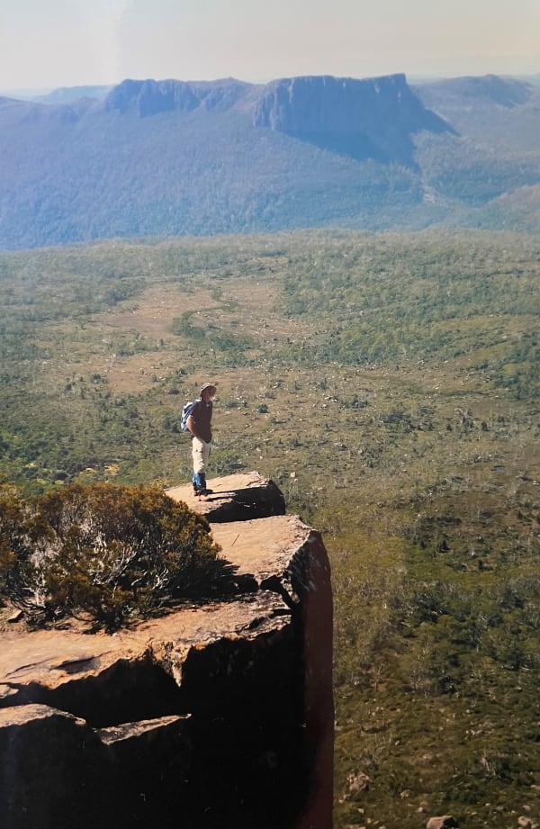
Pelion East is generally seen as the easier side-trip climb for Overland Trackers. And rightly so, because it is half the distance of Mount Ossa from Pelion Gap (which, it should be remembered, is itself of Abel height at 1,113m) and only 300m of climbing as opposed to 500m. However, being easier does not make it easy. It is still the state's 16th highest mountain. It is a steady, then challenging, then demanding climb in which more than 200 steps constructed from recycled plastics give way to stone slabs, then marker posts and finally rock cairns.
Numerous abandoned walking poles signalled the final climb, clearly seen as surplus to requirements with both hands required to scale short vertical sections. In his book The Abels, Bill Wilkinson instructs hikers to "climb over a number of awkward rock ledges, with some exposure". For those still learning Wilkinson’s quirky language, this means it gets very gnarly and not a little bit dangerous near the top.
As with most Abels, the reward is worth the effort with sensational views in all directions. Barn Bluff (1,559m), Cradle (1,545m) and Oakleigh dominate to the north with Pillinger and Cathedral Mountain (1,406m) signalling the Mersey Valley to the east. Over the top of Kia Ora Hut to the south, the Du Cane Range siblings of Falling Mountain (1,482m), Massif (1,514m) and Hyperion (1,480m) line up respectfully. However, the most prominent neighbours are to the west where Tasmania's highest peak, Mount Ossa, looms over Mount Doris, Paddys Nut and Mount Thetis, with Pelion West a brooding, sinister presence beyond.
Few mountains are as instantly recognisable as Pelion East. Although lower than many of the Overland Track peaks, it is usually the first identified in any Abel ID parade due to its distinctive mound-shape capped with a rocky knob. It was formerly called Pretty Sugarloaf, a more attractive, if less practical, name.
Mount Ossa meanwhile, like so many other peaks in this area, owes its name to surveyor George Frankland's love of Greek topography and mythology. It can be climbed in two hours from the same start point as Pelion East. The track skirts around what Wilkinson calls "the insignificant Mount Doris" to a saddle and then gully to the state's rocky rooftop. It may be considerably higher than Pelion East, but is an easier climb. With no point higher on Australia's island state, it is also hugely rewarding. In contrast to my brief stop atop Oakleigh, Ossa would probably hold the record for most time spent at summit, content in shorts and sunlight but surrounded by snow.
After 13 years as a journalist in his native England, Rob Shaw moved to Tasmania with his young family in 2002. He has since continued to write about sport, covering two Olympics, three Commonwealth Games and many other major events, while also exploring the Tasmanian wilderness. His book, Shaw Things, is a compilation of some of his best newspaper columns. It was published by Forty South Publishing.