
photographer Ray Van Engen
When it comes to views, the Abels are like any other real estate: it’s all about location.
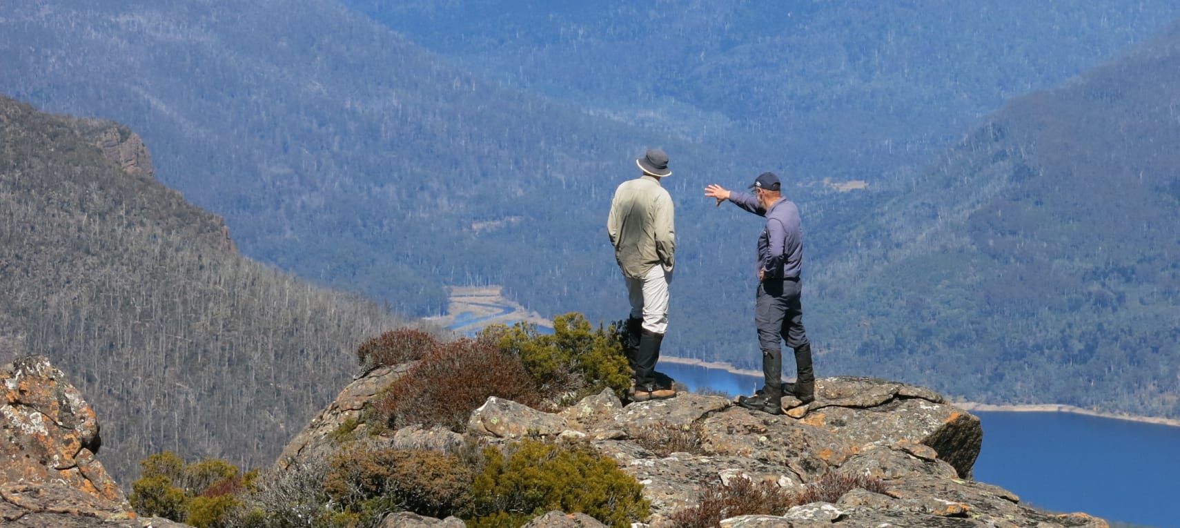
At 1,458 metres, Clumner Bluff is – just – in the top 20 on the list of Tasmania’s 158 highest mountains, as defined by author Bill Wilkinson in his two-volume chronicle The Abels. However, given its location, towering above the eastern shore of Lake Rowallan on the Western Plateau surrounded by sibling peaks, this old friend of mine punches way above its height. There may be taller, and certainly better known, Tasmanian peaks, but for panoramic views, this tops my list.
Of the 50 highest Abels, more than half are visible from the summit of Clumner Bluff, with the select few above 1,500m helpfully identifying themselves by donning snow caps on the day of our visit.
The closest neighbours provide a stunning showcase of the Walls of Jerusalem National Park. Turrana Bluff (1,454m), Mersey Crag (1,420m), Mount Jerusalem (1,459m) and King Davids Peak (1,499m) form a close-knit ring of Abels, complemented by Zion Hill, Mount Ophel, The Temple, Damascus Gate, Solomons Throne, the West Wall, a sprinkling of picturesque tarns and the spectacular drop toilet at Wild Dog Creek campsite.

In the adjoining national park to the west can be seen the full extremities of the Overland Track Abels, from Mount Rufus (1,416m) above Lake St Clair in the south up to Mount Kate (1,156m) above Dove Lake in the north. In between are four of the five highest peaks in the state: Mount Ossa (No 1 at 1,617m), Mount Pelion West (No 3 at 1,560m), Barn Bluff (No 4 at 1,559m) and the park’s eponymous hero Cradle Mountain (No 5 at 1,45m).
Completing the trilogy of complete ranges on view is the Great Western Tiers, with its Abels lining up like a police ID parade, every one of them from Western Bluff (1,420m) to Drys Bluff (1,340m) looking guilty of crimes against vulnerable legs.
But this is only part of Clumner’s charm. Between those peaks, can be seen glimpses of West Coast peaks like Mount Read (1,123m) with its resident weather station guaranteeing a regular starring role in statewide forecasts. Beyond the southern extremity of the Overland and on the other side of the Lyell Highway appears Mount King William I (1,324m) and the distinctive outline of Frenchmans Cap (1,446m).
Black Bluff (1,340m) and St Valentines Peak (1,107m) mark the north-west extremities of the Abel series and, beyond the remaining Walls of Jerusalem peaks, Wild Dog (1,394m) and Sandbanks (1,401m) Tiers headline Great Lake’s contributions to the compendium.
Closer by, Ironstone Mountain (1,444m) is just 14 metres below us and looks a deceptively easy stroll over the plateau, while across Lake Rowallan Nescient Peak (1,125m) and Mount Pillinger (1,270m) signal the valley sides through which the upper Mersey leads the way to the magical Lees Paddocks and Wadleys huts.
Reaching this point had involved a two-hour drive, overnight camp, 7.30am departure and four-hour climb, but even the knowledge that we had to do that all in reverse couldn’t deter us from savouring the panorama. If the Brownlow Medal is the AFL’s night of nights, then Clumner Bluff is the Abels’ view of views.
Having fired up the Peak Finder app to confirm all the above mountainous identifications, we enjoy lunch watching the state rescue helicopter following the shores of Lake Rowallan far beneath us like a scene from Sylvester Stallone’s spectacular but awful film Cliffhanger.
We only truly appreciate quite how high we are when we notice how tiny a boat appears as it makes its gentle way back from a morning fish.
Two wedge-tailed eagles circle above us hungrily, possibly eying weaker members of our party. We later spot their distant raptor cousin, a sea eagle, which shows far less interest in us as a non-fish diet.

We are reluctant to call time on the horizon-gazing – such stunning panoramas and weather conditions rarely coincide. The long return journey, however, demands attention.
We had set out at first light from Fish River Road, off Mersey Forest Road on the eastern shore of Lake Rowallan. Since the far-sighted Wilkinson prophetically wrote, “It should also be noted that a very large tree 1.4km along the road may fall in the near future,” a very large tree 1.4km along the road has opted to have a lay down across it, thereby blocking access to all vehicles.
Bisecting a corner of that road involved a phenomenally-steep short cut after which came an hour or two of forest navigation, eagerly scanning foliage for marking tape, which is not always easy when looking directly into the rising sun. Gradually, the trees thinned out like a receding hairline. Then came a scree field as daunting, sanity-testing and seemingly endless as being stuck in a lift with Donald Trump.
Of the eight hours we spent on the mountain, about half was spent bonding with scree – a rocky relationship if ever there was one. Wilkinson’s descriptions of “extensive awkward scree” and “a tremendous jumble of large boulders” don’t do it justice.
“Care needs to be employed on some surfaces where black lichens create a very slippery surface when damp,” he adds. “The way becomes a rock hop and some slightly awkward boulders need to be moved through.”

This is Bill-speak for: brace yourself for hours of clambering over an Ice Age worth of rocks, many bigger than your family car with a delightful tendency to wobble unnervingly when stepped upon. Have fun.
Even on the glorious day we had stumbled upon, there were still clumps of snow as well as some delightful patches of ice on higher boulders that appear to experience a somewhat fleeting and frosty relationship with the sun.
After painstakingly picking our way along the cairned route, we finally crested the ridgeline. This is undoubtedly one of the most rewarding experiences Abel bagging offers, not only for the stunning views, but the resulting easy 400-metre skip to the summit cairn.
Wilkinson was also in his element when he reached this point.
“This location becomes increasingly wondrous,” he writes. “A base to … contemplate the [surrounding peaks] within a realm of absolute silence and blissful solitude.”
As with most of our Abel expeditions, we had recorded our efforts on the marvellous exercise app, Strava, so can definitively report that, over a total distance of 7.47km, we had completed an elevation gain of 1,005m.
The mountain was originally named Clumpers Hill Bluff by surveyor James Scott, subsequently inaccurately reported as Clumners Hill Bluff on James Sprent’s map of 1859, and then shortened to today’s name. So not only does it present a vertical kilometre and a scree field from Hades, but its very name is a typographical error.
Great view though.

More in the ABELS series: