
The ABELS: Tasmania has 158 mountains which are classified, according to criteria established in 1973, as Abels. Reaching the top of all 158 of them has been named, by Lonely Planet, as one of the world’s 10 great composite climbing challenges. In this regular column, well-known sports and adventure writer Rob Shaw leads us on some definitive Tasmanian adventures.
Legend tells of a magical lost valley, hidden from civilisation, dominated by twin peaks, guarded by serpents and reached by a secret, fairy tale path beneath huge overhangs, up sheer climbs and behind wondrous waterfalls.
Secret might be stretching things a tad since it all appears on the 1:25,000 Pillans map of central Tasmania, but there was certainly a Lord of the Rings feel to our adventure into the lesser-explored northern fringes of the Walls of Jerusalem National Park.
Occasionally, geography, meteorology and sheer determination combine to enable the conquering of two or even more Abels in one day. The Little Fisher River Track provides such an opportunity and a convenient avenue to neighbouring mountains which both exceed 1,400 metres and therefore sit comfortably in the top 30 of Tasmania’s 158 highest peaks, as defined by author Bill Wilkinson in his two-volume chronicle, The Abels.
Mersey Crag (1,420m) and Turrana Bluff (1,454m) had long loomed as our final conquests within a national park which has so much more to offer than the traditional route march from its whizz-bang new car park and long-needed toilet block, via Trappers Hut to the established camping spots at Wild Dog Creek and Dixons Kingdom.
The most recognised route to the mountains, as detailed by Wilkinson who calls it “a more pleasant alternative”, takes hikers off the Trappers Hut track and through the Golden Gate and Zion Vale to the wonderfully Norse-sounding Lake Thor, from where both can be conquered in a day.

However, the same could be said about the Little Fisher River valley (not to be confused with the Fish River running parallel to the Trappers track) reached from an earlier spur off the Mersey Forest Road in less time and with a bit of transportational creativity.
A flood-damaged bridge may have become impassable to four wheels but not two and we had decided that mountain bikes could be used to make a sizable dent in the hiking time.
With a three-day, two-night schedule, this meant riding with overnight packs and while the plan did slash a probable three-hour, 12km trudge down to a 90-minute cycle, riding on a rocky, damp, albeit relatively-level surface with 17 unsteady kilograms on your back, is an acquired skill, and also taste.
Three recently-rebuilt footbridges made up for the lack of the road bridge and eventually we ditched the bikes in dense undergrowth (no need to lock them out there) and swapped wheels for the more familiar mode of feet.
The next hour took us through a beautiful myrtle forest to Rinadeena Falls, one of countless undersold, accessible, picturesque Tasmanian waterfalls which would consider double-figure visitation to be a busy day but could expect many times that, every hour, if unfortunate enough to have been located in Europe.
Sharing a name with a largely forgotten railroad siding off the Lyell Highway east of Strahan, rinadeena is of Aboriginal origin and means “raindrops”. The falls are stunning at any time but simply captivating when sunlight makes the water sparkle. Huge, waterlogged mosses somehow cling to its rock face and reach an almost unnatural shade of green. Like many Tasmanian cascades, there is the chance to walk behind the drop and peer out through the curtains of the waterfall.

While the falls are a popular day walk, the track continues beyond, although becoming far less distinct as it wanders into Tolkien territory. In addition to being harder to follow, it is also harder to walk as it suddenly heads upwards, reaching such a gradient that in a couple of pinch climbs, ropes have been fixed to aid walkers.
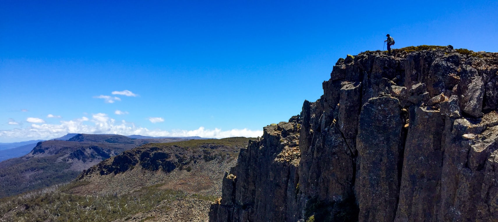
Before long, the objects of our expedition begin to loom high either side of the track, the twin peaks signalling the approach to the glacial gateway between them.
We camped in the valley, marginally closer to Mersey Crag but suitably positioned to admire the full extent of Turrana’s lengthy, jagged bluff towering above us to the east and making the most of the late afternoon sunlight. Such had been our ascent that even our camping spot was above the minimum Abel height of 1,100m.
The following morning, it took 45 minutes to walk up through the gap towards Long Tarns from which both peaks were to be accessed.
Marginally lower, and seemingly closer, Mersey Crag (named for its proximity to the upper Mersey) was first on the list.
As we were following the Abels “bible”, it may be sacrilegious to say the instructions left much to be desired and, with minimal cairns to follow, we made a few unnecessary detours and held animated discussion about the inadequacy of our route description. Bill Wilkinson’s suggestion that the summit would be reached in 45 minutes would have fans of The Castle commenting, “Tell him he’s dreamin’.”
The resultant wandering did introduce us to some amazing, if awkward, terrain and rock features of monumental proportions. Such was the dearth of cairns that we even built the summit version ourselves.
Views to the south and west of the Walls of Jerusalem and Overland Track peaks made all the effort worthwhile, although the eastern perspective was somewhat more intimidating as it revealed the daunting distance awaiting us to ascend Turrana. With just 34 metres separating the heights, a cable car or chairlift would not have been out of order.
Turrana Bluff was also poorly marked, but then Abel bagging is not meant to be easy and, with no real track or cairns on offer, the afternoon adventure consisted of pointing at the summit and simply taking the most direct route towards it, whatever rocks, head-high scoparia or even hidden tarns, lay in the way.
The largest of the latter was simply sensational, framed by cliffs and copses of pencil pines and every bit as photogenic as the better-known, and certainly more-visited, Artists or Wombat pools around Cradle Mountain.
A day of false summits continued, each tantalising us with a hint of approaching conclusion only to deliver the reality of another extension to the exertion. As we climbed, the mischievous gang of Mount Pelion West, Barn Bluff and Cradle Mountain could be found playing peek-a-boo in the gaps between the high points of Mersey Crag to our west.
In the Abel pack, views trump effort and Turrana dealt us another ace.

Continuing the rinadeena trend, turrana is an Aboriginal word for snow and presents a series of individual peaks which jut out from the rugged ridgeline, offering a magnificent panorama of surrounding peaks on the horizon, Mersey Crag across the valley and our tiny tents more than 300m far below us.
The knowledge of our proximity to a terrifying drop did little to dampen the enjoyment of a 360-degree spread of Abels, each delightfully identified over a gourmet course of squashed sandwiches and half-melted chocolate.
To the east is an area variously referred to as “the land of a thousand lakes” or “land of 3,000 lakes”, presumably depending on the extent to which one wishes to exaggerate. Either way, it is well named, presenting a patchwork of countless tarns between the Walls of Jerusalem and Central Highlands, which must make foot navigation something of a nightmare.
Another hour of relentless bush-bashing through prickly scoparia reunited us with the Little Fisher River Track which led us back to camp for a night of curry, warm port and annoying mosquitoes while watching the sun retreat on the wall of Turrana Bluff. There was also time for a dip in a convenient tarn, with the resulting ice bath proving about as popular with over-worked feet as they are with over-paid footballers.

The day’s efforts totalled eight and a half hours, but that included lengthy stops at both summits, much photography, a spot of navigational nuttiness plus the ensuing debates on the best way forward.
After the enjoyment of sharing photographs on a day when weather and scenery had combined with jaw-dropping potency, we retreated to our separate tents.
The walking out day began with the delight of waking up at one of the most remote but still accessible spots on the planet. It’s an experience not confined to Tasmania, but few places do it better.
More in the ABELS series: