
Photographers ROB SHAW and CRAIG SEARLE
A regular question asked by Abelists – that select, slightly obsessed and possibly deranged group of hikers dedicated to scaling Tasmania’s highest peaks – is whether they would tackle certain mountains again. Is there sufficient satisfaction in merely ticking off another of the 158 designated 1,100-metre-plus peaks, or has the experience been so enjoyable it requires repeating?
For a peak which for most people falls into the “never again – not even under threat of torture” category, Mensa Moor has a surprising amount going for it.
One of several classified Abels within Ben Lomond National Park, it was also the sixth and final one viewable from my house to be bagged. For 15 years, I had gazed out from my Launceston home at a horizon featuring, from left to right, Mount Arthur (1,187m), Mount Barrow (1,420m), Legges Tor (1,575m), Ragged Jack (1,369m), Stacks Bluff (1,528m) and Mensa Moor (1,365m) with the goal of scaling each.
Respectively ranked (according to height) 109th, 31st, 2nd, 48th, 6th and 51st on author Bill Wilkinson’s definitive league table of Tasmanian peaks, the first five had been achieved with varying degrees of difficulty. Mount Barrow and Legges Tor were simplified considerably by roads leading to within sight of their summits. Arthur was a fun excursion from both sides while Ragged Jack and Stacks Bluff were full-day ventures, yielding both stunning views and phenomenal amounts of scree.

Mensa Moor, however, always sat in the too-hard basket – a daunting nine-hour slog with a name sounding like some location from Wuthering Heights. According to Wilkinson – the self-described “inventor” of the Abels, whose designations require a 150m drop on all sides – Mensa Moor was “not to be tackled lightly”.
While Legges Tor, at 210m higher, has been graded “easy”, its near neighbour is considered “hard”, accessible across “trackless, open, alpine moors” and described with similarly unflattering words like “featureless”, “untracked”, “thick scrub”, “poorly-drained” and “false top” with the dreaded “rock scree” thrown in for further discomfort. Even the subject in an accompanying picture in Wilkinson’s book, The Abels, can be seen dressed in full ski gear.
According to the book, Mensa Moor can only be reached from the ski village atop Ben Lomond, necessitating a long hike across alpine terrain followed by the formidable hurdle of descending, and then re-climbing, the state’s second highest mountain.
“This Abel should only be climbed by experienced walkers,” Wilkinson advises. “The lengthy walk is at high altitude and the open plateau offers very little shelter if the weather deteriorates.” And here’s the clincher, “Note the instability of the compass.”
So, nine hours across unmarked terrain, in unpredictable weather, nearly 1,500m up with unreliable navigation. It wasn’t exactly yelling, “Come climb me.”

However, the combination of some enterprising adventurers and a chance meeting with Bill Wilkinson opened an alternative avenue to this slumbering giant. Equally keen to avoid the aforementioned romp, some fellow Abelists had proven Mensa could be successfully tamed from the west, via Deddington, Nile, through many meandering forestry tracks and good use of orienteering skills. Wilkinson confirmed this might be achievable.
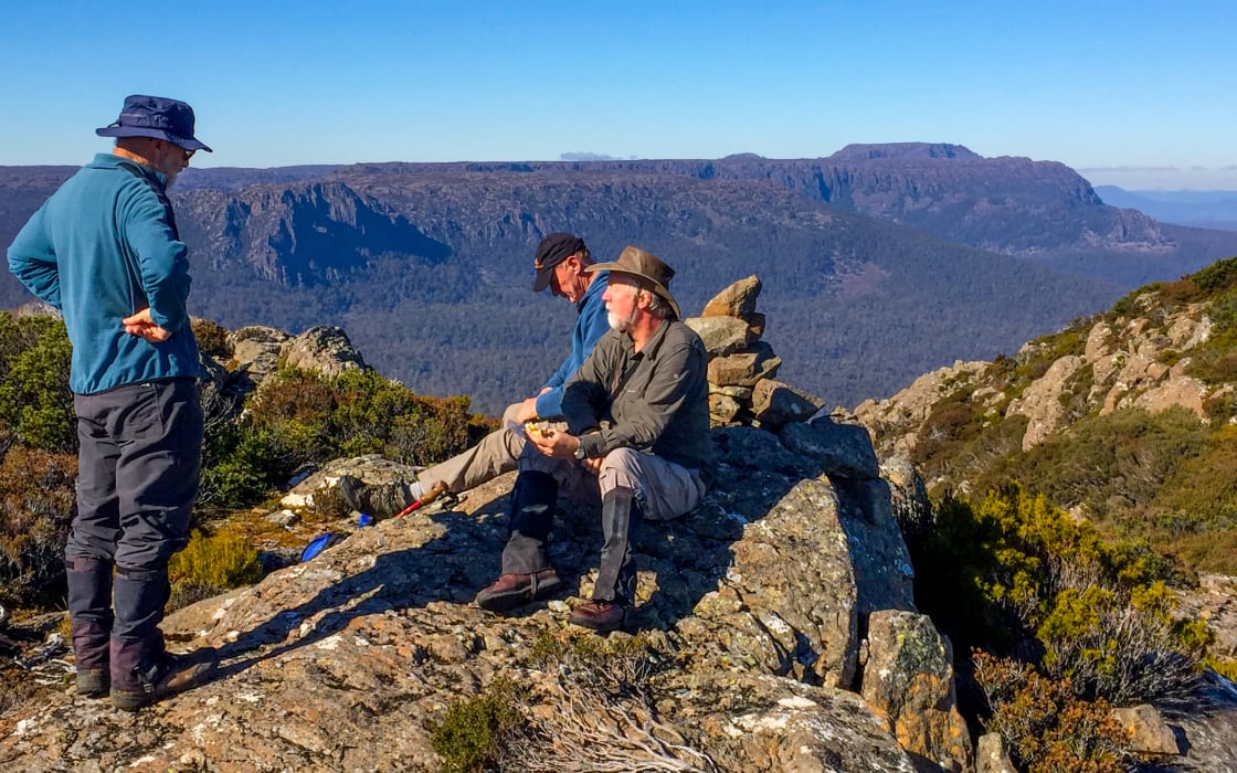
Deciding to follow their footsteps, Craig, my fellow adventurer, and I found ourselves venturing along assorted tracks off Deddington Road on the sort of glorious summer’s day that makes Tasmanians forget about their long winter. In the absence of a convenient, ready-made track, our mission, should we have chosen to accept it, was to follow a compass bearing through whatever terrain lay in our path until we had crested the mountain’s western escarpment to meet the track coming from Ben Lomond’s ski village.
After rock-hopping across a small creek, we began the lengthy process by which Craig would regularly consult the compass and instruct me to head for specific landmarks. However, as the terrain consisted of trees – lots of them and little else – instructions were generally along the lines of, “Head for that gum tree. No, not that one, the one leaning a bit, between the two slightly larger ones. No, not that one, the other one just like it.”
Both time-consuming and friendship-testing, this process led, inevitably, to much hearty discussion about the degree of accuracy with which one tree may differ from a thousand others. We had a splendid time and laughed lots.
Carefully marking our route with coloured tape, we also noticed we were not the first to do so as we clearly followed a similar heading to our Abel predecessors. Eventually, and indeed, mercifully, we emerged from the dense bush to be reunited with every Abelist’s most fearsome adversary, scree.
Scree is basically a river of rocks of indeterminate size which no self-respecting Abel is seen without. While offering a welcome break from scrub, a scree field can be an unpredictable place, particularly when apparently fixed boulders, some the size of family cars, choose to teeter on their chosen foundations. We call these wobblers. Wobblers are great fun and frequently lead the other regular member of our expeditions, Ray, to emit naughty words.
While scree is virtually obligatory for all Abels, surely none possesses as much of it as the superbly-named Rats Castle. So called because it was used as a base and lookout by bushrangers, the 1,393m peak west of Great Lake boasts the Amazon of Abel scree fields. If you ever fancy several hours of ankle-straining, wobbly frustration, park on the Highland Lakes Road just north of Reynolds Neck and head west up Brandum Creek. Telling someone about to climb Rats Castle they may encounter some scree, is akin to telling someone about to swim the Pacific Ocean they might get wet.
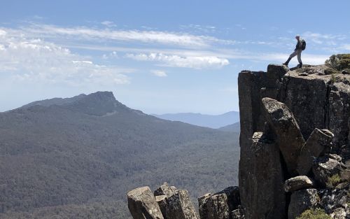
Back on Mensa Moor, and finally free of vegetation, we were able to fix a point on the horizon and scree hop to our hearts’ content. Clearing the ridgeline, we traversed the aptly-named moor to the domed summit on the south-east corner of the peak, about which Wilkinson has accurately stated, “There is a definite feeling of remoteness.”

. . .
With unrestricted views to Ragged Jack, Legges Tor and Stacks Bluff, it is worth remembering that of all the land in Tasmania above 1,500m, 85 per cent of it is found on the Ben Lomond plateau. Holding that thought while consuming squashed sandwiches and gazing into the seemingly bottomless abyss of Speke Gorge, we retraced our steps with a smug satisfaction at having slashed the peak’s recommended climb time.
However, a combination of the lengthy navigational process combined with a surprisingly hot day and lack of fresh water on the peak soon dominated proceedings. Stiffness swiftly replaced smugness as dehydration kicked in.
Like Frodo and Sam’s mission to Mount Doom, the return journey seemed endless, energy-sapping and full of peril.
However, spurring on every toe-twisting, calf-contorting step was our knowledge of a refreshing stream awaiting us by the car. Enticed home first by a beautiful, trickling sound, then glimpses of crystal-clear running water, we collapsed at its edge and drank as much as was humanly possible. Then we paused, and drank some more. Once fully sated, we continued drinking, just to be safe.
After a final drink, we filled water bottles for the drive home to a long-awaited view of six bagged Abels.
More in the ABELS series: