
Photographers Rob Shaw, Craig Searle and Ray Van Engen
It is 2.18am. I am warm, dry and comfy in my sleeping bag, and the only sensory intake is the strangely melodic chorus of insects chirping, frogs croaking and my hiking companions snoring.
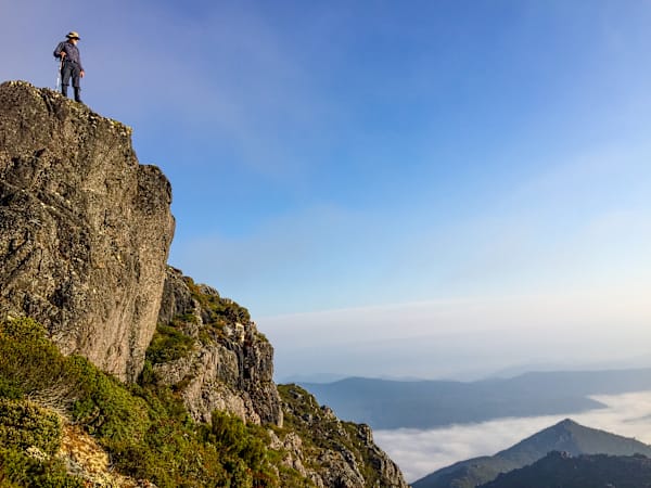
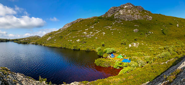
Less than two metres from my tent is Paddys Lake, the most northerly glacial tarn in Tasmania, and looming large over that is the formidable, moon-lit outline of Black Bluff, with all the menacing presence its name suggests.
If the 1,339-metre peak is the object of my quest, then Paddys Lake is my win bonus. It is the sort of remote, idyllic location of which Tasmania has plenty. When I posted pictures of it on social media, born-and-bred Tasmanians commented on its beauty before asking for clarification of its location. So plentiful are its secrets that even the most travelled continue to discover new ones
Our island state specialises in such wilderness seduction.
Such is the girth and proximity of Black Bluff that the sun disappeared behind it well before 6pm, even though I am here in high summer and I have been able to sleep with the side of my tent open to enjoy the changing lake view throughout the night.
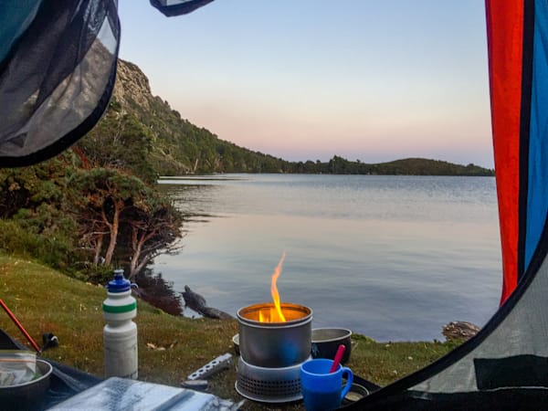
When I first snuggled down, the water was placid and deathly still. Now, it is cloaked in a sinister blanket of low cloud, drifting up from Loongana some 700 metres beneath us in the Leven Valley. The first rays of morning sunlight, in a couple of hours, will restore its beauty.
Black Bluff is one of Tasmania’s 1,100m-plus peaks as designated by author Bill Wilkinson in his two-volume guide to the state’s highest mountains, The Abels. Requiring a 150m drop on all sides to make the cut, there are 158 of them and, since Wilkinson published his detailed guides, they have become extremely coveted by the bushwalking fraternity.
The appeal is not just in bagging another peak; it is in discovering places like Paddys Lake, which also happens to be a recommended camping spot on the Penguin-Cradle Trail – a 75km, five-day trek linking Tasmania’s scenic north coast with its most photographed mountain.
The Abels can be easily divided into several regions, and indeed are in Wilkinson’s books. The north-east offers a sporadic collection, mostly within sight of each other but sufficiently distanced to maintain their own character and individuality – like neighbours hosting simultaneous parties but all determined to play their own favourite music.
The Central Highlands area shepherds peaks together in a rough collection around the windswept Great Lake, offering views to all corners of Tasmania.
The south-west is the epicentre of Abel activity, but with so few roads and so much virgin terrain awaiting, is generally marked on maps with the words: “There be dragons.”
Black Bluff, in the north-west, makes up in adventure what it lacks in abundance.

It was named for its dark appearance when first viewed, and indeed climbed, by Henry Hellyer in 1828. It is beyond Leven Canyon on the C128 road south from Ulverstone with South Nietta the closest thing to a settlement.
The peak can be reached either by heading south on Brookes Track from Arthurs Bridge at Loongana or via Maxwells and Tramway tracks, which includes the picture-postcard Winterbrook Falls, from the east.
We opted for the former, with a three-hour uphill rocky trudge the price we had to pay for paradise. Five thousand metres horizontal for 700 vertical.
While snakes and leeches seem to attract the most concern, of just as much danger to hikers are jack-jumpers – vicious, angry and aggressive members of the ant family that specialise in biting first and asking questions later. Brookes Track is the centre of the jack-jumper universe. Along some stages, we could barely walk 10m between giant nests. As a result, pauses were positively discouraged. Fortunately, the kilometre-plus height of Paddys Lake appeared to be beyond the capacity of the twitchy varmints.
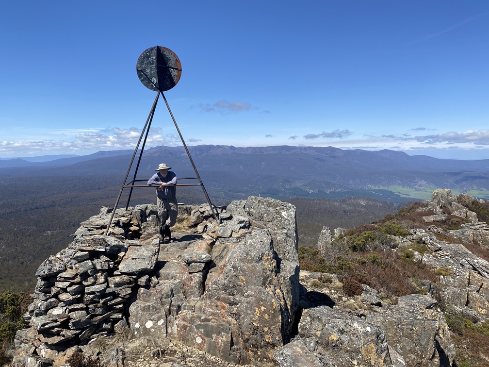
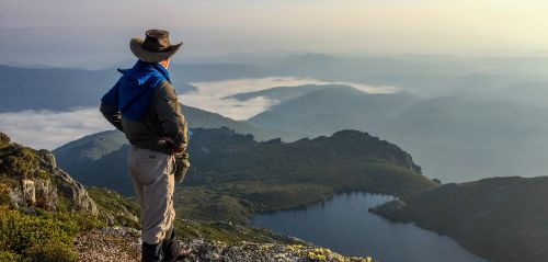
Black Bluff’s trig point is an easy 40-minute meander up from the lake, passing some stunning natural viewpoints with vistas north towards Bass Strait or south to the distinctive outline of Cradle Mountain (1,545m), Barn Bluff (1,559m) and their sibling Overland Track peaks.
St Valentines Peak, the most north-westerly Abel and only just making the cut at 1,107m, wins the horizon’s volcano lookalike competition, behind nearby Mount Tor (1,110m), while Mount Roland (1,234m) dominates the view to the east.
I share this, and most of my Abel expeditions, with my regular hiking companions whom I shall call Roy and Chris to avoid identification and potential libel action, although their real names are Ray and Craig.
Chris is our planner – a bit like Richard Attenborough in The Great Escape – although he looks more like the actor’s Jurassic Park incarnation. Co-ordinator, researcher and navigator, there is nothing Chris won’t do for a couple of days in the wilderness and the chance to beat us at cribbage.
Roy is our resident photographer and trip chronicler. Steady of pace but sharp of eye, he frequently spots fauna and flora missed by the less naturally attentive. We always smell the roses more when Roy is with us. Countless times we have paused upon noticing there are suddenly only two of us present, to discover Roy has stopped to snap a particularly photogenic leech.
Wilderness is where we find spiritual enlightenment and The Abels has become our bible, although, worryingly, this analogy does appear to paint Wilkinson as some god-like figure.
Anatoli Boukreev, the legendary Russian mountaineer who summited Everest several times without oxygen, was an integral part of the mass rescues of 1996 and died in the Himalayas a year later, put it best in a quote which appears on The Abels website, “Mountains are not stadiums where I satisfy my ambition to achieve. They are the cathedrals where I practice my religion.”
We celebrate our latest Abel conquest with familiar rituals. Self-congratulatory handshakes (this was pre-coronavirus), the obligatory selfie and a ceremonial march back to the campsite for a shot of something we can only safely consume in the knowledge that none of us is driving in the immediate future. Such substances have an uncanny habit of sneaking into our packs, often explained away as potential treatment in the case of a medical emergency but almost exclusively reserved for marking such moments of achievement.
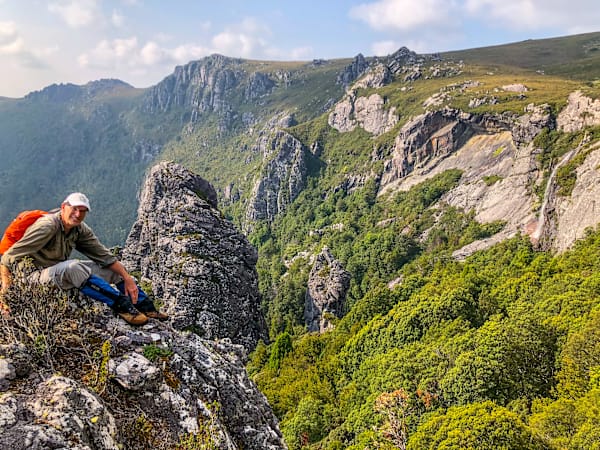
Heartily recommended as a brief detour to this peak is Winterbrook Falls. It may be a couple of hundred metres off the track as the currawong flies, but benefits from time to explore and photograph. Scrambling around a particularly precipitous escarpment, we locate the aptly-named Prominent Rock and gaze down on the sort of scene that could barely have changed since the subjects of the latter Attenborough character’s fascination were roaming around eating each other and treating the looming Ice Age with the same disdain mankind initially showed for Covid-19.
Running the jack-jumper gauntlet for the second time, we reluctantly return to civilisation and such niceties as fresh food, social media and thick mattresses.
I never thought I’d miss Roy’s snoring.
More in the ABELS series:
- Nescient Peak
- Mensa Moor
- Mount Ironstone
- Clumner Bluff
- Frenchmans Cap
- Drys Bluff
- Mount Murchison, Mount Dundas
- Mersey Crag, Turrana Bluff
After 13 years as a journalist in his native England, Rob Shaw moved to Tasmania with his young family in 2002. He has since continued to write about sport, covering two Olympics, three Commonwealth Games and many other major events, while also exploring the Tasmanian wilderness.