
If global warming was to get a little ahead of itself and Tasmania become flooded to a height of 1,400 metres, two-thirds of the remaining land would be on the Ben Lomond plateau.
However, the second-largest remaining island may surprise many.
It is not anywhere along the Overland Track, the Walls of Jerusalem nor even the rugged and mountainous south-west.
Instead, it can be easily viewed by any motorist making a sedate trip through the rich agricultural pastures along the Bass Highway between Devonport and Launceston.
In fact, take such a journey with a Tasmanian mountain climber in your passenger seat and it may seem several times longer as they painstakingly detail all the peaks visible while the Great Western Tiers glide by to the south.

Tasmania beneath another 1,400 metres of sea water would consist of a handful of sporadic islets mostly dotted along the now-submerged Overland Track, a mainland with a newly-designated central business district around the Ben Lomond ski village and a 300-hectare island around Ironstone Mountain.
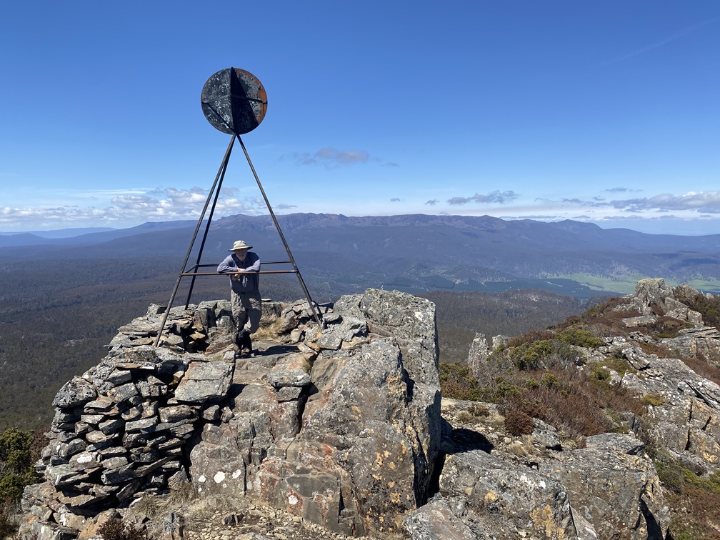
This is not due to Ironstone’s significant elevation – far from it, at 1,444m, there are 21 higher mountains around the state. Moreover, its lofty status derives from the significant plateau it sits upon, north-west of Great Lake and almost equidistant between Tasmania’s west and east coasts.
Add to this the variety of routes to its summit, plus its name deriving from an ability to affect compasses, and it looms large as a must-do among the exclusive list of Tasmania’s highest mountains.
Meticulously chronicled in author Bill Wilkinson’s two volumes of the same name, the Abels are named after 17th-century Dutch explorer Abel Tasman, the first European to sight any of them, whose surname was also adopted to rebadge their island home, and Ironstone can be found midway between Western Bluff and Drys Bluff before the Tiers, and indeed the Midland Highway, take a dramatic swerve southbound.

It can be conquered from at least three clearly defined directions. Ironstone Track approaches from the east and links up with access via either Deli Track or Mother Cummings Track. To the north, Western Creek and Higgs tracks offer routes via Whiteley’s or Lady Lake huts respectively, the latter being the setting of magical, early overnight wilderness adventures for both my offspring.
However, the slightly longer option of walking from Lake Mackenzie in the west carries with it the equally appealing prospects of overnighting at Ironstone Hut without having to climb the escarpment carrying full packs.
One of the joys of an Abel expedition is the planning, and Ironstone had been discussed many times on previous hikes with my fellow Abelists.
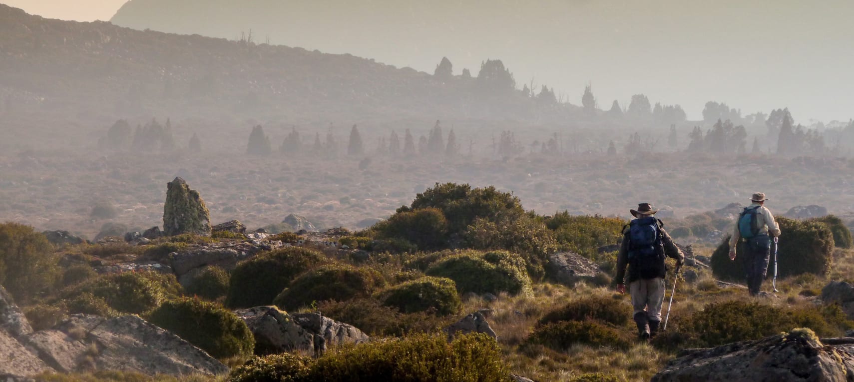
Nobody needed much convincing to go for option three and after driving to the end of Lake Mackenzie Road and parking just beyond the turnoff to Devils Gullet, we followed its southern shoreline before heading up the aptly-named, Explorer Creek, to its predictably-named source, Lake Explorer. Another southern shoreline traverse took us on to the ominously-named, Snake Lake, and then the bizarrely-named, Lake Nameless.

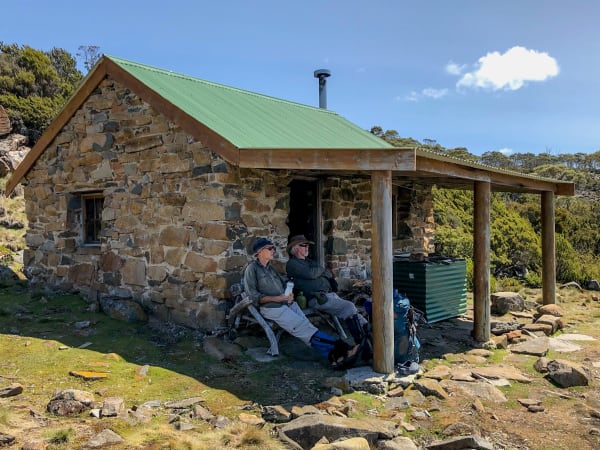
Here we linked up with Higgs Track and headed to the lake’s south-west corner to find, arguably, the finest of Tasmania’s many wilderness huts. Built in 1917 by Sydney Higgs, Ironstone Hut was intended to attract more trout fishers to the Chudleigh Lakes highlands area. It proved so successful in this that the Deloraine community invested a sum of £41 for a boat to be bought and carried to Lake Nameless where a stone boat shed was built. Not only are the remains of the shed still visible, but so is the outline of the dilapidated boat in nearby shallow water.
Over time, the quality of the fish, the hut built to accommodate those trying to catch them and the track intended to facilitate the process, all deteriorated.
Mountain historian Simon Cubit, whose book Tasmanian High Country Huts (Forty South) is as beautiful as its accompanying illustrations from Des Murray, paints a vivid picture of the building’s decline. “By the middle to late 1950s,” Cubit writes, “with rain and snow entering at will and the wind able to get in under the roofing iron, the hut was in a sad state.”
As chairman of the then newly-formed Mountain Huts Preservation Society, Cubit took on “the lack of enthusiasm expressed by the Parks and Wildlife Service” to oversee a complete rebuild between 1993 and ’95. Described as “an event of enormous significance”, the project helped reclaim not just a run-down, half-forgotten structure but the highlands themselves.
As Cubit concluded, “To many local people, the rebuilding of the Ironstone Hut represented a victory against those that have tried to take away the mountains and the meaning they held.”
Consequently, experiencing a night at Ironstone Hut (or two, with the conquering of its namesake Abel in between) is a uniquely Tasmanian pleasure that every fit, outdoor-loving Tasmanian should consider.
Built on a solid, bare-stone floor, it consists of one room with half a dozen bunks, a fireplace and a decidedly wonky table. The solitary doorway leads to a small verandah and an elevated view of the lake. A couple of minutes’ walk away is a toilet which, like so many of its ilk in the Tasmanian wilderness, has no door to guarantee a loo with a view. If a more tranquil location for a daily discharge exists in this state, my bottom is yet to sit on it.
Separating our two nights of hearty meals, keenly-contested card games and the obligatory consumption of port, came the object of our expedition.

Despite sharing names, the hut and mountain are hardly close neighbours, although a third member of the Ironstone clan, a lake, does adorn the foothills of its sizable sibling. But the mountain can be seen from the hut, dominating the eastern horizon, particularly when it has caught the evening sun.
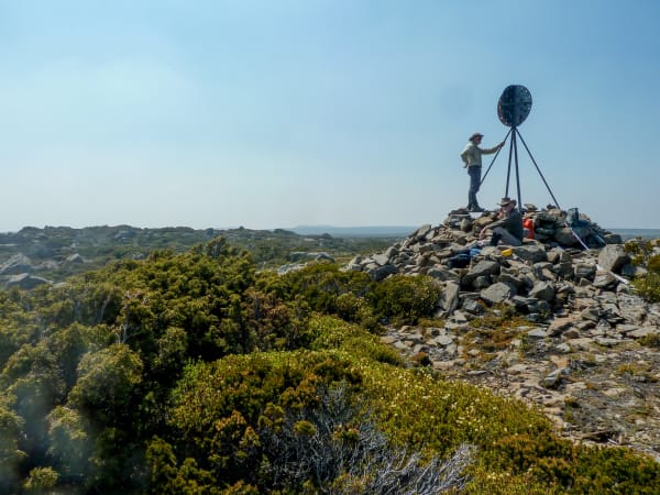
Our walk involved careful, but not difficult, navigation around the two lakes and across flat, open scrub with scattered pencil pines before embarking on a lengthy and taxing scree field on the mountain’s western slopes. Rock cairns arrived late to our party to guide the final ascent of an unmistakable plateau, or, “large level expanse”, as Wilkinson calls it.
Bass Strait formed the backdrop of the northern view, although Cradle Mountain (1545m), Black Bluff (1340m), Western Bluff (1420m), Mount Roland (1234m), Cummings Head (1260m), Quamby Bluff (1228m), Ben Lomond (1575m) and Drys Bluff (1340m) helped to fill in the gaps. The Abels encircling Great Lake hogged the scene to the south, including Rats Castle (1393m), Wild Dog Tier (1m higher) and Sandbanks Tier (7m higher still), while Mount Ossa (1617m), King Davids Peak (1499m) and Mount Jerusalem (1459m) hinted at the close proximity to the state’s more marketed national parks.
In a clearing, way beneath us, the distinctive brown, corrugated iron of Whiteley’s Hut could be made out, the scene of the 2002 helicopter crash involving more community-minded members of the Mountain Huts Preservation Society.
Meanwhile, just out of view to our east, was the source of the Meander River, beginning its existence with a precipitous plunge over Bastion Bluff which I had viewed several times from beneath as Meander Falls.
The view, combined with the captivating appeal of Ironstone Hut and the companionship of like-minded adventurers, was worth three days of anybody’s time.
More in the ABELS series: