
Attempting to describe the appeal of Frenchmans Cap is not only challenging but also unnecessary, since explorer Tom Moore did it perfectly 134 years ago.
“If there be an Elysium on Earth, it is this. Poets and artists would feast with enraptured eye on its glories and immortalise its splendour with pen and brush.”
Yeah, what he said.
To anyone not studying Gallic headwear of the late 18th century, Frenchmans Cap is one of those phrases instantly evocative of Tasmania, alongside “The Roaring Forties”, “controversial dams protest” and “under-represented in national sporting competitions”.
The term relates to a striking 1,446-metre peak recognisable from almost all sides due to its formidable quartzite cliffs. It featured in Marcus Clarke’s harrowing novel For The Term of His Natural Life, has been immortalised by Antarctic photographer Frank Hurley and was the beacon of hope and freedom for fleeing Sarah Island convicts led by notorious cannibal Alexander Pearce.

photo Craig Searle
Once regarded as Tasmania’s most remote and defiant peak, it boasts the state’s tallest cliff face and is described on an information board at the start of the walking track as, “One of Tasmania’s most challenging, most spectacular and most rewarding bushwalking experiences.”
Contrast that with the opinion of surveyor and bushman James Sprent who, in 1853, wrote, “I have never met, in all my experience of ascending mountains, one so difficult of access. The spurs are very irregularly placed and preserve little continuity. They are riven asunder by chasms hundreds of feet deep, presenting a fearful abyss to the cautious traveller.” Curse those irregularly-placed spurs.
Frenchmans Cap, or “The Frenchman” as it is frequently described in bushwalking tales, towers over neighbouring peaks like a basketballer in a room full of jockeys. Visited by convicts, governors, explorers, prospectors, piners, hunters, bushwalkers, rock climbers and photographers, it has a mesmerising hold over all who have seen it and is among the quintessential mountain experiences of not just Tasmania, but Australia.
Situated in the 4,463 square-kilometre national park called Franklin-Gordon Wild Rivers, the peak has a geological history dating back 700 million years. Its interaction with humanity is somewhat shorter, but no less seismic.

photo Craig Searle
Its first ascent is the subject of considerable controversy.
Surveyors William Sharland (1801-77) and James Calder (1808-82) were thwarted by such hurdles as an “impassable chasm” before Polish explorer Paul de Strzelecki (1797-1873) tried his luck in 1841. He almost certainly succeeded but a lost diary and faulty barometer failed to provide proof.
Twelve years later, James Sprent (1808-63) nearly made it, instead dispatching a team of hardy convicts who built a huge summit cairn of quartz rocks and pandani trunks to record their success.
So, despite numerous surrounding features carrying the names of so many who fell short, the identities of those who achieved the first confirmed ascent was never recorded.
However, our friend Tom Moore (1850-1919), with his wonderful descriptive talents was credited with the first successful ascent from the west, which he achieved from Queenstown in 1887 sporting a distinctive thylacine pelt cap.
A track was cut by another surveyor, John Philp (1869-1937), in 1910, a national park declared in 1941 and the first hut built at Lake Tahune in 1947.

help with much of the climbing
photo Rob Shaw
Since those early days, Frenchmans Cap has become a must-do for bushwalking enthusiasts, particularly following the publication of Bill Wilkinson’s two-volume chronicle, The Abels. Detailing Tasmania’s 158 mountains over 1,100m, it has The Frenchman at No 21.
Once 52km, the walk has been trimmed down following a welcome re-routing in the last decade, financed by a $1.1 million donation from entrepreneur and philanthropist Dick Smith, who has been a regular visitor to the region for more than half a century.
Destroyed in the 1966 bushfires, Lake Tahune Hut was rebuilt in 1971 and then again in 2018. The hut at Lake Vera was built in 1962 and replaced in 1978, funded by a bequest from the family of late Launceston bushwalker Michael Higgins.
The walk is listed as three to five days. We took four (two nights at Vera, one at Tahune), which seemed a reasonable schedule, but encountered others who did it in: three (which generally meant one night at each hut); two (a ludicrous schedule which began and ended with drives from and to Hobart relying on a single night at Tahune); and even one (an ultra-runner we passed on the way out, set on completing more than a marathon over ankle-breaking, wet, tree roots. Good luck with that.)
Day one consisted of parking on the Lyell Highway, 30km west of Derwent Bridge, before heading in, initially west and then south. Making use of two splendid suspension bridges, we crossed the Franklin and Loddon rivers, both infamous with Tasmanian adventurers for vastly different reasons.

photo Rob Shaw
The Franklin is one of Australia’s most untamed wilderness features. Anybody who could dismiss such a majestic creation as “a leech-ridden ditch”, as then Premier Robin Gray did at the height of the aforementioned controversial dams protests of the 1980s, needs to get out more. This walk would be a good start.
Meanwhile, the poorly-drained floodplains of the Loddon and South Loddon rivers, whose energy-sapping, deep mud have struck fear into generations of bushwalkers and coined the term, “the Sodden Loddons”, are now bypassed with a higher, and shorter, track to the north called Laughton’s Lead.
After five hours of walking, we arrived at Lake Vera Hut.
Day two began with the most gruelling section of the trip.
Having carefully edged around the northern shore of Lake Vera, the track headed westwards and upwards, through a magical rainforest filled with Huon, King Billy and Celery Top pines. Countless tree roots and damp, mossy stones combined with a height gain of 360m in 3km made for a brutal climb.
However, the track has some delightful features, particularly the numerous ladders made from notched logs.

photo Craig Searle
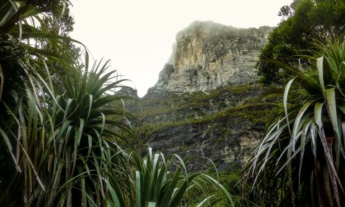
All spent effort is rewarded when the two-hour trudge ends at the well-named Barron Pass, gateway to the bizarrely-named Artichoke Valley. Suddenly, the scenery is jaw-droppingly stunning. Abels abound from the fearsome face of Sharlands Peak (1,140m) to Philps Peak (1,282m), Agamemnon (1,238m) and the sinister, distant promise of Clytemnestra (1,271m); all under the parental gaze of Frenchmans (1,446m) which dominates the western horizon.
Traversing an often-exposed ridge, the view is complemented by lakes named Millicent, Magdalen, Gertrude and Cecily which, along with Gwendolen, Nancy and Sophie further west, abide by the naming convention of explorers Moore and later Charles Whitham, who deemed they must have feminine names “to suit their capricious loveliness”.
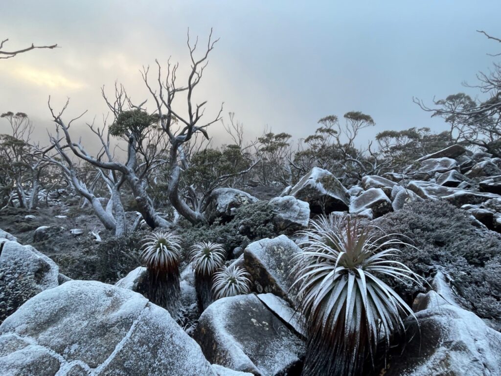
A final descent brought us to Lake Tahune and one of the highest and best mountain huts in Tasmania. The notoriously fickle weather dictated a late afternoon summit would not be possible, but the gradual emergence of the peak, delightfully framed by raindrop-coated pandani plants, suggested a dawn assault was the go.
Leaving the hut at 5.15am on day three, we spent 45 minutes climbing by torchlight, the faint outline of peaks visible only by the light of a crescent moon.

photo Craig Searle
Gradually, the sun neared the distant horizon, making the normally white quartz glow orange. Way beneath us, pockets of cloud filled valleys looked like glaciers of mist flowing down to warmer climes.
Having ascended 450m from Lake Tahune Hut, we summited at 6.30am.
There may be 20 higher mountains in Tasmania, half of which I have climbed, but never before had I experienced such a feeling of being on top of the world. There can be few more invigorating and spiritual experiences than a sunrise from a mountain top, especially one that takes two days to reach.
A kilometre and a half up and 15 from the nearest road, we watched in respectful silence as surrounding scenery emerged from its gloomy slumber, spanning Macquarie Harbour on the western horizon to the Overland Track peaks in the east. Clytemnestra, which until this point had always towered above us, now cowered below like a floored boxer slumped against the ropes.
The euphoria of achievement was soon numbed. The wind-chill factor on top was almost as staggering as the mountain itself, prompting the appearance of beanies, gloves, fleeces and overcoats and much sheltering behind what has remained of a summit cairn.

photo Craig Searle
For a mountain synonymous with sheer cliffs, the summit is surprisingly domed and almost flat although a brief wander in almost any direction leads to precipitous plunges. But for the biting wind, and the thought of the return journey ahead, we could have stayed all day, reflecting on how an expedition to Frenchmans Cap is about so much more than just bagging the summit.
Reluctantly, we descended, warmed by the glow of the sun on neighbouring Lions Head, had breakfast and packed up before retracing our steps away from this Elysium and back towards civilisation, walking as much on air as rock, soil or wood.
More in the ABELS series: