


If such a formation was situated in almost any other developed country, it would surely be a massive tourist destination; in Tasmania it can exist in relative anonymity, unknown even by the vast majority of the state's residents.
photographers ROB SHAW, SCOTT GELSTON and MARTIN HULCOOP
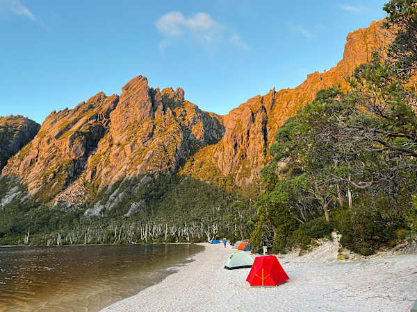
It is possible to pay a graphic artist a large sum of money to search Google Images for "classic rocky mountain" and "perfect sandy beach" and then merge them with Photoshop. Or you could invest a Tasmanian Parks and Wildlife pass and visit Lake Rhona.
Situated 900 metres up in the Denison Range overlooking the Gordon River valley in the heart of the rugged south-west, language simply cannot do it justice. I could say idyllic, picturesque or even utopian. Inadequate.
The white beach, which would look more at home on a Queensland island than a Tasmanian mountain, borders a tannin-stained lake cradled by fearsome conglomerate peaks towering nearly 400m above. It has become a Mecca for bushwalking photographers keen to capture one of Tasmania's most stunning views, as identifiable as Cradle Mountain across Dove Lake or the Lake Oberon shot immortalised by Peter Dombrovskis.
In addition to its inherent beauty, Lake Rhona also happens to be the perfect base from which to tackle three Abels – those Tasmanian mountains above 1,100 metres – providing inconveniences like the state's fickle weather and largest river (by volume) are in agreeable moods.
Four days in such a location provides sufficient soul food to satisfy the most demanding of appetites. Camping in the soft quartzite sand, after washing off the sweaty toils of the hike in with a bracing dip in Rhona's waters, is one of Tasmania's unheralded joys.
Curious currawongs provided the only audible accompaniment as we devoured hard-earned chocolate and watched the shadows lengthen as the afternoon sun crept behind the jagged horizon, offering a final funnel of rays through one giant gully like a miner taking one last look over his shoulder before descending into the gloom.
Lake Rhona is reached by a six-hour hike preceded by a drive through the maze of forestry roads north-west of Maydena. Taking the Florentine Road northwards through one of the hotbeds of the Tasmanian forestry debate, Tiger Road and Range Road lead to a car park with the assistance of convenient small hiker signs at each junction.
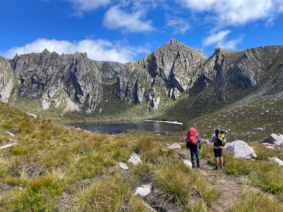
A relatively new track following Richea Creek takes you to the reason why this hike has become so notorious and the subject of many unnecessary rescues. Flowing south into the vast lake which shares its name, the famed Gordon River presents a formidable obstacle and its water level dictates whether any expedition into the Vale of Rasselas is possible.
At its lowest, the river is not a difficult crossing. Fallen trees provide a relatively easy, though hardly health and safety compliant, route while wading across would barely get the knees wet. However, any rain transforms the situation – the fallen trees vanish with impressive speed beneath a fast-flowing current.
Consequently, with most hikers taking on multi-day trips, what was a simple crossing on the way in can be impossible upon return. In January, a group of bushwalkers from Victoria made a satellite emergency call and were subsequently extracted by rescue helicopter after finding themselves in this very scenario. Their story is not unique.
So please note: up-to-date rainfall and river heights are not only monitored but available online from Hydro Tasmania, and should be used to determine all plans. The obstacle should not be taken lightly. There is a good reason why this national park is called the Franklin-Gordon Wild Rivers.
Information boards at the beginning of the walk state: “The Gordon River can flood quickly and without warning” and “All walkers MUST be prepared to wait until river levels subside before crossing safely. Always take extra food and other supplies in case you are delayed on your return.”
Meanwhile the Tasmania Police press release about the stranded Victorians concluded, rather tactfully, with lengthy tips about remembering to be prepared.
Once across the Gordon, the Rasselas Track opens the door to Mount Wright (1,112m), Reeds Peak (1,290m) and Bonds Craig (1,260m) plus several more further-flung peaks for the committed Abelists.
After a while climbing Tasmania's mountains, it is only natural to start comparing them. Features, gradients, profiles and even workloads are inevitably put up against each other and many similarities noticed. However, the state's ability to produce something unprecedented should never be underestimated.
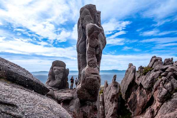
Just days after discovering the jaw-dropping beauty of the limestone sinkhole Growling Swallet (a short distance back along Florentine Road), Wright's Arch had the same "how did we not know about this?" effect, albeit at the opposite end of the altitude spectrum.
Unusual rock formations are hardly unique in this geological paradise, with the cave near the top of Mount Owen above Queenstown demonstrating they can occur where least expected, but the huge rock archway three-quarters of the way up Mount Wright left us as breathless as the climb to reach it (745m in a bit over 2km).
Although visible from the base, it is only upon arrival that the structure's stunning size hits home. About 30m across and 10m high, it provides a natural bridge – to be crossed only by the foolhardy. If such a formation was situated in almost any other developed country, it would surely be a massive tourist destination; in Tasmania it can exist in relative anonymity, unknown even by the vast majority of the state's residents.
Perhaps half of our experience on Mount Wright was spent admiring, photographing and negotiating the arch, but it was time very well spent. Obviously, we knocked off the summit (at only just over the 1,100m benchmark, it is ranked 145th of the 158 Abels), but this was a mere obligation after Wright's main attraction.
Back on the Rasselas Track, the 12km to Lake Rhona is broken up by the abandoned Gordonvale property of the late Tassie hermit Ernie Bond, a succession of welcome freshwater creeks and finally a punishing 300m climb.
Reeds Peak and Bonds Craig combined represent one of the best double-Abel days on offer. A four-hour trek if doing just the former, the duration doubles to include the latter but the rewards are worth the investment.
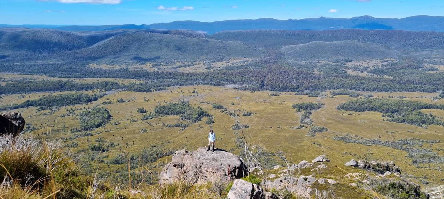
Circumnavigating Rhona in a clockwise direction, altitude is steadily gained as both the amazing views and the impact of the 2019 bushfires become more obvious. The southern ridgeline offered the finest viewpoint as our distant tents became ever smaller blobs of colour on the magnificent landscape.
Approaching Reeds Peak from the south via Great Dome, phenomenal rock formations began to emerge, gigantic protrusions thrusting out high over the lake creating an eerie moonscape, demanding photography.
Although conical, first summited within the last century and the highest point in the range, Reeds Peak was surprisingly easy to scale before attention turned to the second significant item on the day's agenda. Two kilometres north along a jagged ridge, Bonds Craig (named after Ernie, not James) was a challenging but satisfying addition. Identified by dual peaks of almost exactly the same height, the Abel is 30m shorter than its sibling peak but an impressive mountain in its own right, affording views as far afield as Frenchmans Cap, the Western Arthurs and Walls of Jerusalem, but dominated by nearby Mount Field.
Returning to the campsite led to hearty meals, nightcaps, an impromptu juggling session and vigorous retelling of the day's adventures.
We were lucky with the weather. Four days without precipitation is a rare occurrence in an area with an annual rainfall of 1,900mm, but we were able to safely cross the Gordon a second time and head for civilisation.
When the water level and weather window combine favourably, Lake Rhona and its three neighbouring Abels represent one of the best mini-hikes Tasmania has to offer, and that's a high bar.
It is also substantially more real than anything Google or Photoshop could ever generate.
Rob Shaw was born and raised in England where he trained and worked as a journalist. Coming to Australia in 2002 with his young family was supposed to be temporary, but Tasmania had other ideas. He has since spent his time working as a sports reporter, exploring our state’s wilderness and realising that he is staying here for the term of his natural life.


