
The ABELS: Tasmania has 158 mountains which are classified, according to criteria established in 1973, as Abels. Reaching the top of all 158 of them has been named, by Lonely Planet, as one of the world’s 10 great composite climbing challenges. In this regular column, well-known sports and adventure writer Rob Shaw leads us on some definitive Tasmanian adventures.
“So, are you guys fishermen or what?”
The man’s North American origins were evident from both the accent and rhetorical question.
“No, we’re climbing mountains,” declared Alan, triumphantly.
It was actually just mountain – singular – but Alan later said that sounded a bit lame, so he pluralised for dramatic effect. We also weren’t really climbing as just walking up a gradient. It wasn’t as if we had backpacks full of ropes and carabiners hidden in the car.
And, technically speaking, our target was not even called a mountain as its name is Clear Hill.
All of that aside, I’m very glad Alan didn’t tell this inquisitive American fellow, who had obviously spent much of his evening pondering why four middle-aged blokes would be having a night in somewhere as remote as the Pedder Wilderness Lodge, Strathgordon, that we were there to walk up a hill.
Known as the Lake Pedder Lodge and Strathgordon Chalet in previous incarnations, the accommodation is the perfect base for a couple of far-flung but relatively easily-conquered Abels – that collection of 158 Tasmanian mountains above 1,100 metres, each requiring a minimum drop of 150m on all sides, as defined in author Bill Wilkinson’s The Abels, volumes one and two.
To be fair, it is also virtually the only accommodation available beyond the rest of civilisation, starting at Maydena about an hour further east along the B61 (constructed to service the building of the Gordon Dam in 1974).
Some, indeed many, Abels require lengthy trudges through life-sapping mud and scrub, sharing damp, uncomfortable makeshift campsites with Tasmania’s resident leech population. Others involve a comfy night in a warm bed with hot showers, a few beers with like-minded mates and a creamy vegetable pasta to die for before an enjoyable hike up a couple of conveniently-located peaks. Take your pick.
Having plumped for the latter option, I opted to accompany the pasta and beer with a chocolate dessert, particularly having learned from the typically-wordy menu description that it featured an essence of thylacine. It may have been immature, but I couldn’t resist asking the waitress, “Where do you source your thylacine?” She smiled politely with a look which was somewhere between, “That’s funny,” and, “I don’t hear that every night of my life.”
Like the B61, which provides its umbilical link to the outside world, Strathgordon was created solely for the purposes of the nearby 140m-high structure holding back Australia’s largest lake. Half ghost town, half living museum, it is the ideal starting point to climb Clear Hill (1,198m) and Mount Wedge (1,148m), both accessed off the Gordon River Road. Mount Mueller (1,245m), The Thumbs (1,204m), Stepped Hills (1,111m) and Mount Wright (1,112m) are also in the vicinity.
It is also the best place from which to savour views of lakes Gordon and Pedder and pay homage to Darryl Kerrigan by pondering, “How’s the serenity?”
In separate trips, and contrasting weather conditions, we tackled the easiest two.
In truth, we were not expecting much from either mountain, and in that respect Wedge did not disappoint. But Clear Hill was fabulous and hardly deserving of such an unflattering name. It is a mountain in every respect.
Mount Wedge may well be just as good, but we graced it on a bad day, spending about one-tenth as long on the summit and experiencing one-hundredth of the views.
About 43km west of Maydena, the Mount Wedge Forest Reserve car park represents the starting point. Named in 1835 after surveyor John Helder Wedge, who was searching for the headwaters of the Huon River and whose route would eventually form the basis of today’s Gordon River Road, its ascent was described by early conquerors as “arduous”. It hasn’t significantly improved, but the five-hour return walk is on an easy-to-follow track and would be considerably more rewarding in better weather.
It begins with an interpretive nature trail before veering into dense eucalypt rainforest via a clearance for cables taking power from the Gordon Dam to Hobart. As the altitude increases, the eucalypts give way to sassafras, myrtle, tea tree and pandani before a rocky ridge leads to what Wilkinson describes as the “rounded shoulders” of the summit. He also talks romantically of the stunning views across Lakes Gordon and Pedder, but low cloud denied us the privilege and somewhat warped our view of what is probably a delightful walk. In our case the highlight of the summit was the welcome shelter offered by the telecommunications shed and wooden helipad.
After the Mount Wedge experience, we were not keen to go all that way again for the same result. Fortunately, our enthusiastic trip organiser – an experienced meteorologist to boot – rarely gets it wrong twice in a row. So, with total trust in his weather-reading skills, we hit the highway to the south again.
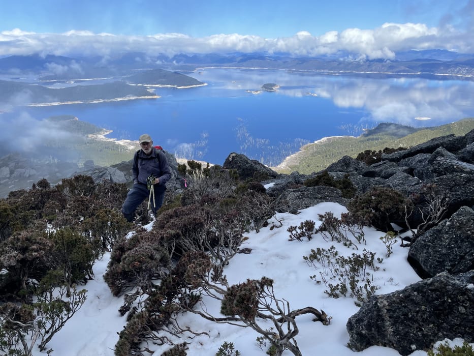
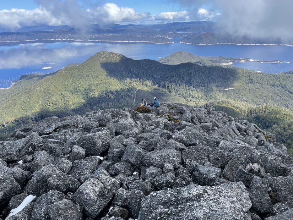
Located on a peninsula sticking out into Lake Gordon, about 25km west of Maydena then 22km north, Clear Hill offers panoramas of lake and mountains with the bonus of a view straight up the raging Gordon River gorge as the waterway embarks on its journey through the Franklin-Gordon Wild Rivers National Park towards Macquarie Harbour.
The first 15 minutes of the hike involves a steep muddy track through dense bauera and cutting grass, which made for much slipping, sliding and swearing.
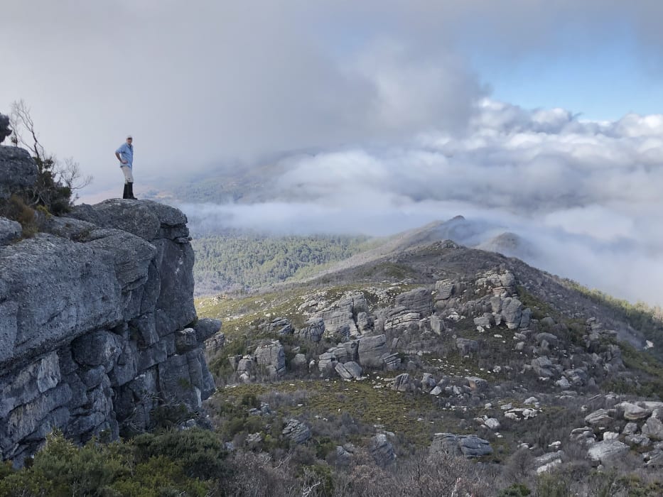
We emerged onto a ridgeline to be greeted by huge lumps of conglomerate rock sculpted into shapes resembling a variety of mythical creatures – depending on the viewer’s alcohol content and quality of vision. Stunning and captivating, it was like a Tasmanian tribute to Western Australia’s Bungle Bungles.

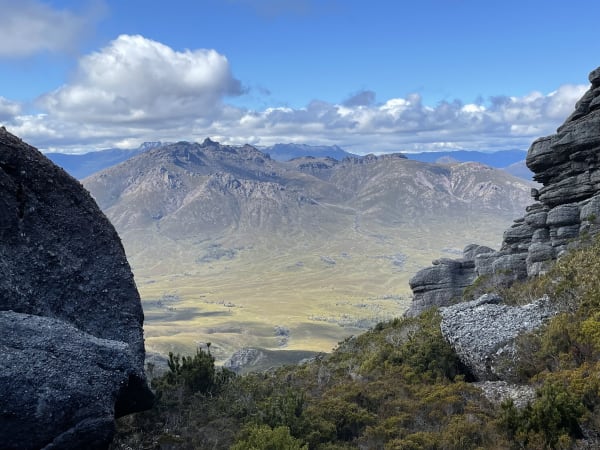
As we climbed, low cloud dispersed to reveal magnificent views across to The Thumbs and the snow-capped Mount Field National Park to the east, old friend Mount Wedge to the south, the Frankland Range to the west, Snowy Range to the south and a northern panorama from Frenchmans Cap on the horizon to Reeds Peak in the foreground. Mount Anne, Hartz Peak and Federation Peak completed the mountainous compendium.
The nearest neighbour, just to the north across where Boyes Basin feeds into the Gordon Gorge, Stepped Hills was a glorious sight pointing towards the Denison Range. Angled rock strata give way to a series of exposed western ridgelines like the wrinkles on the neck of an old lizard. Enchantingly highlighted by the afternoon sun, it spoke of an Abel adventure for another day and a further example of a mighty mountain patronisingly dismissed by being forever known as just a hill.
Equally intoxicating was the prospect of The Thumbs, 5km due east, where a jagged line of sibling peaks is accessed along the exposed Packers Spur from the abandoned settlement of Adamsfield, established in 1925 following the discovery of osmiridium (currently valued at about US$400 per ounce if you fancy some fossicking).
The vast Lake Gordon encroached all around us, giving some indication of what 12,359,040 thousand cubic metres of water actually looks like.
Almost exactly due west we could see through Junction Narrows to Pleiades and Holley basins, which in turn feed Pearce and Knob basins through Twelvetrees Narrows just north of Strathgordon and its famed thylacine desserts. With no wind to speak of, and the sky a vivid blue, the reflections were crystal clear. Framed by snow in the foreground and wispy cloud above, it was a photographer’s delight.
I sent one such photograph to a colleague I had been sitting next to in a Launceston office 24 hours earlier. His reply expressed disbelief that we were in the same country, let alone state.
Such is the delight of climbing mountains – or indeed walking up hills – in Tasmania.
More in the ABELS series: