
photographers ROB SHAW and RAY van ENGEN
In the league table of what constitutes a good Abel, some surprising candidates can be found among the playoff positions.
The overall title would almost certainly be decided among Tasmanian peaks which require a reasonable amount of effort and yield a similar degree of satisfaction, such as the state’s highest, Mount Ossa (1,617m), its most famous, Cradle Mountain (1,545m), and perhaps its most viewed, kunanyi/Mount Wellington (1,271m – assuming you don’t just drive up).
But not far behind such well-known giants are others that come close to rivalling them for height, adventure and enjoyment, if not fame. Many are largely unknown, even to knowledgeable, outdoor-loving Tasmanians.
Parson and Clerk is one such example. At 1,210 metres, the mountain doesn’t even break the top 100 in Bill Wilkinson’s definitive list of Tasmania’s 158 peaks higher than 1,100 metres (each requiring a minimum drop of 150m on all sides), as detailed in his two-volume chronicle, The Abels. On a classic Abels checklist, however, Parson and Clerk doesn’t leave many boxes unticked, or indeed boulders unturned.

Ideally, an Abel should include: an assortment of tracks and terrain; some degree of self-navigation; a bit of rock climbing and scree hopping (but not so much that your nightmares are filled with boulders for ensuing weeks); an intriguing discovery or two (such as a hunter’s shack); stunning views; and simply being a peak you almost certainly would never have visited had Bill Wilkinson not adjudicated it as making the cut.
Parson and Clerk is all the above, and some.
It sits between Abel siblings Sandbanks Tier (1,401m) and Millers Bluff (1,213m) at the eastern end of the Great Western Tiers where Tasmania’s barren, windswept Central Plateau descends to seemingly endless sheep paddocks through which the Midland Highway links the state’s largest two cities.
Wilkinson waxes lyrical about the spot in Volume 1 of The Abels, describing it as, “The most conspicuous landscape feature of Tasmania. To the west, the mountains continue unabated for 145 kilometres across a wide front to almost reach Zeehan. This is a great proportion of the width of Tasmania, which totals only 250 kilometres,” he writes.
“Lying at the very heart of Tasmania, the plateau typifies the essential character of the state. A massive dolerite sheet resting on thick sandstone and mudstone layers, which reveal themselves on the lower slopes of the Great Western Tiers, the plateau’s surface is a network of interconnecting flat, lake-studded expanses; there are only 21 Abels despite its vastness.”
At the risk of being excommunicated by the God of Abel-bagging, this was another expedition where we didn’t adhere to the gospel according to Saint Bill. His directions detail a passage from the east via the C522 between Cressy and Campbell Town. We had already taken a similar route to scale Millers Bluff and decided it all sounded very similar and, in truth, too easy.
Approaching instead from the west offered not only a refreshing alternative but the chance to avoid climbing a 600m escarpment. Abelists can be as lazy as they are adventurous.
Letting four wheels rather than two legs take the strain by scaling the Tiers via Poatina Hill, we headed east along Gunns Marsh Road and past several popular Arthurs Lake fishing spots like the superbly-named Cowpaddock Bay. Veering north-east, we drove on to Gunns Lake where we parked and began the hike with a short hop to the larger but confusingly-named Little Lake.
A four-wheel drive track continued for much of the route, pleasant underfoot and even easier if we had brought mountain bikes, which will surely accompany any return.
Fat tyre tracks suggested vehicle movements beyond the last signs of regular human habitation as the trail traversed a picturesque combination of open moors and sporadic forest. Landscape reminiscent of the splendid 2011 Tasmanian film, The Hunter, had us scanning the low-lying scrub for possible sightings of either the last thylacine or, indeed, Willem Dafoe.
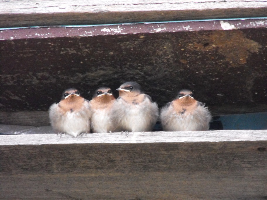
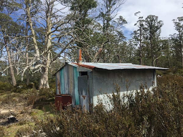
The hunter’s shack was a fascinating bonus, situated towards the end of the marked track and as full of intrigue and character as it was drafts and corrugated iron. Constructed on a floor of stone slabs, it had a fireplace and table and optimistically suggested it could accommodate eight – that number of sleeping platforms carefully designated with figures cut from assorted car licence plates. Chopped firewood sat in a neat pile just waiting to warm up a chilly night or two as swallows nested among the roof beams, spoilt for choice as to which of many gaps they could use to access the great outdoors. Scribbled messages adorned the walls, most individually dated and recounting tales of happy hunting adventures.
Many such rustic huts can be found across the Tasmanian wilderness, mostly the work of hunters, trappers or anglers. They are capable of providing emergency shelter when the highlands indulge in their notorious meteorological unpredictability. This particular one was by no means the least hospitable we have stumbled upon.
After a brief pause for fruit and chocolate, we pushed on and were soon approaching the most adventurous part of the expedition.
My hiking team of three is not averse to a spot of self-navigation, providing it’s not of the sort that ends up as a news report beginning, “Police have issued warnings about poorly-prepared bushwalkers … ”
Having trekked as far as we thought we could go up Poachers Creek gully, we knew we were within reachable distance of our objective, but were also aware we would have to tackle dense bush, a steady gradient, occasional scree and no distinguishable track. In such circumstances, we turn to that faithful old mate, a compass, follow its bearing and do everything in our power not to deviate from its advice.
Gum trees, gum trees, and more gum trees had become our default screen saver. This meant much bush-whacking, frequent rock-hopping and a fairly constant audio accompaniment of unprintable observations about the wisdom of not sticking with Bill’s original route description.
It was on this leg of our adventure that we made our chance discovery. Well-hidden beneath dense scrub and long since blanketed in a thick layer of moss, was a stash of about 25 steel rabbit traps. Carefully piled together and mostly still in working order, the collection appeared to have been untouched and forgotten for decades. Subsequent enquiries suggested the devices – now illegal to use in Tasmania – would have been owned by a trapper and rather than carry them out, were piled up for use in the next season. The extent of their rust and the thickness of the surrounding bush suggested they had been undisturbed for many years. Almost certainly, whoever left them had long since gone the way of Dafoe’s last thylacine.
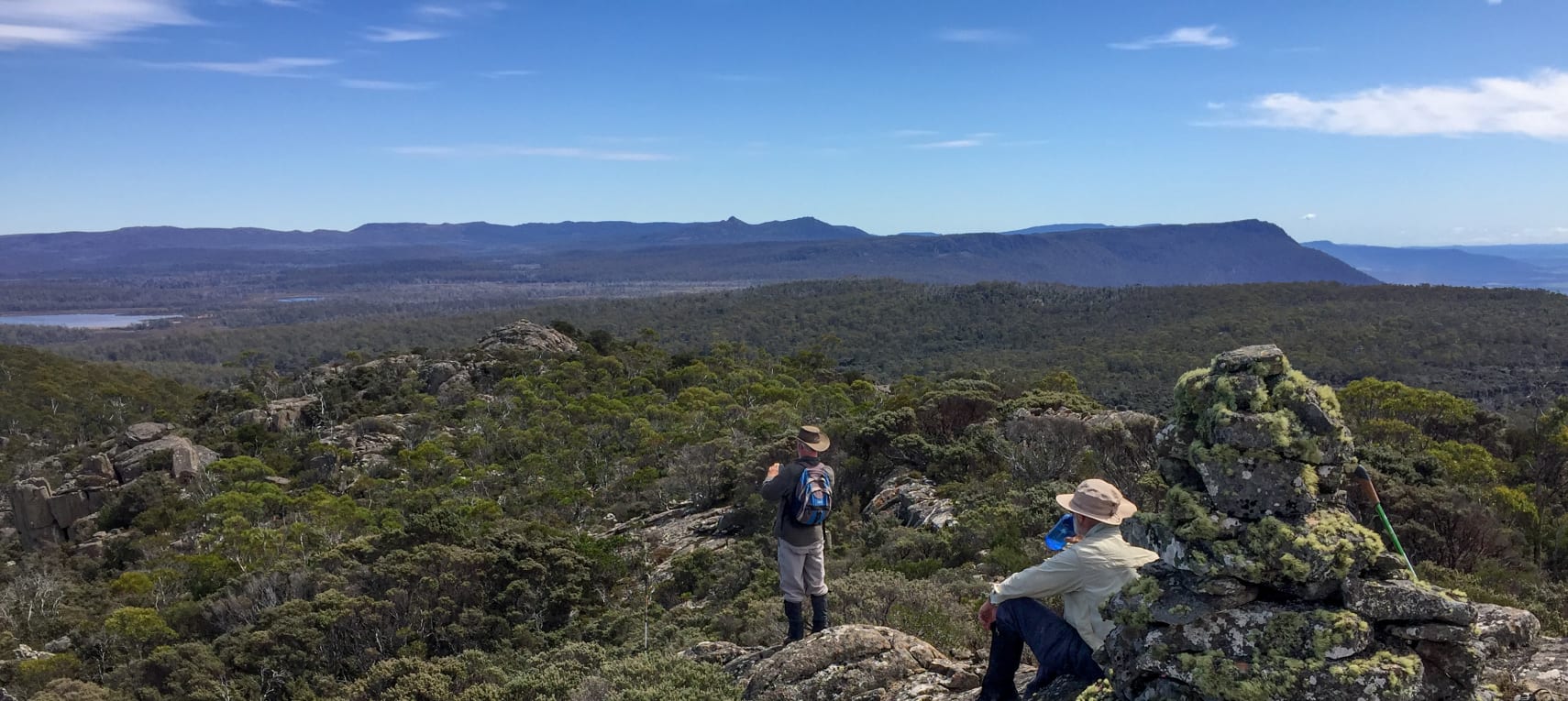
Eventually, our efforts yielded views behind us across Little and Arthurs lakes, and then, suddenly, and quite wonderfully, the sight of a rather welcome summit cairn dead ahead. The navigational dream team of Craig Searle and his compass had come good, as Ray Van Engen and I always knew they would, having never doubted them at all.
That last sentence may not be entirely true.
A final spot of gaiter-testing scrub-bashing brought us to the moss-covered pile of stones, although this, in turn, revealed the nearby second summit of similar height. Apparently, the twin peaks are responsible for the mountain’s double-barrelled name, bestowed on it in 1807, when a Lieutenant Laycock became the first European to cross the island. It would take more than a century before the area became regularly visited as engineers began to develop its hydro-electric potential.
As scaling both summits does not represent two Abels, we just savoured the views of the first with an accompaniment of cheese rolls, much hearty back-slapping and the obligatory selfie and panorama photos.
No Abel conquest is complete without an extensive survey of surrounding peaks which traditionally degenerates into arguments over identification requiring resolution by the highly-recommended debate-settling app Peak Finder. Gazing east across the Tamar Valley towards the extensive plateau of Ben Lomond, it was easy to imagine Lt Laycock slogging his way up-state more than two centuries earlier, happily bestowing colonial names on passing peaks which had been familiar to indigenous residents for millennia.
Tick off another excellent adventure which we would almost certainly never have enjoyed but for the fiendish genius of wild Bill Wilkinson, whose efforts to draw attention to some of Tasmania’s lesser-known peaks warrant him getting the last word on the subject.
“In climbing these Abels, the walker will encounter a wide variety of landscapes and be exhilarated by the unique empathy which makes the Central Plateau a marvellous place for bushwalking.”
More in the ABELS series:
- Nescient Peak
- Black Bluff
- Mensa Moor
- Mount Ironstone
- Clumner Bluff
- Frenchmans Cap
- Drys Bluff
- Mount Murchison, Mount Dundas
- Mersey Crag and Turrana Bluff
- Clear Hill and Mount Wedge
After 13 years as a journalist in his native England, Rob Shaw moved to Tasmania with his young family in 2002. He has since continued to write about sport, covering two Olympic Games, three Commonwealth Games and many other major events, while also exploring the Tasmanian wilderness. His book, Shaw Things, is a compilation of some of his best newspaper columns. It was published by Forty South Publishing.