
Lake Myrtle is the sort of place every visitor falls in love with upon first sight, and then pledges to keep secret for fear of having to share its beauty with madding crowds.
photographers ROB SHAW and RAY van ENGEN
Usually, the most satisfying part of climbing an Abel is reaching the summit. Whatever the view, weather or prevailing mood among the travelling party, this is the moment that makes all the effort worthwhile.
But then there is Mount Rogoona, which redefines the experience of conquering one of Tasmania’s highest peaks. The summit selfies, the smug satisfaction and the obligatory high fives were nothing compared to the relaxed sense of achievement that followed a couple of hours later.
In that time we had completed all the summit rituals, descended more than 300 metres, returned to the camping spot where we had begun the day, taken a chilly dip to freshen up, changed into clothes that didn’t smell like an ultramarathoner’s socks, and were reflecting on our achievement in one of Tasmania’s countless hidden idylls with a tipple carried in just for this moment.
Lake Myrtle is the sort of place every visitor falls in love with upon first sight, and then pledges to keep secret for fear of having to share its beauty with madding crowds. I am anticipating instant excommunication from the Lake Myrtle Appreciation Society by sharing this information now.
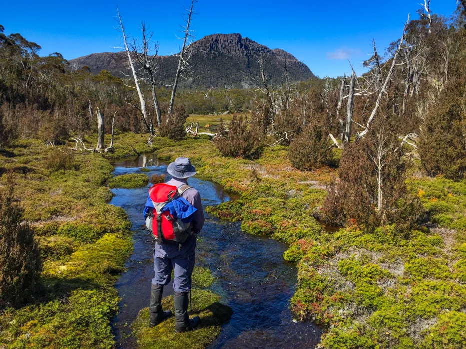
It exists, much as it has for several million years, in relative anonymity between Cradle Mountain-Lake St Clair and Walls of Jerusalem national parks, a few kilometres south of Lake Rowallan and the end of Mersey Forest Rd, which affords access to so much of central Tasmania’s wonderful wilderness.
It is surrounded by natural features with names as captivating as their appearance: Mountains of Jupiter, the Never Never, Du Cane Range, Chinamans Plains, Great Pine Tier, Traveller Range, Blizzard Plain and so on.
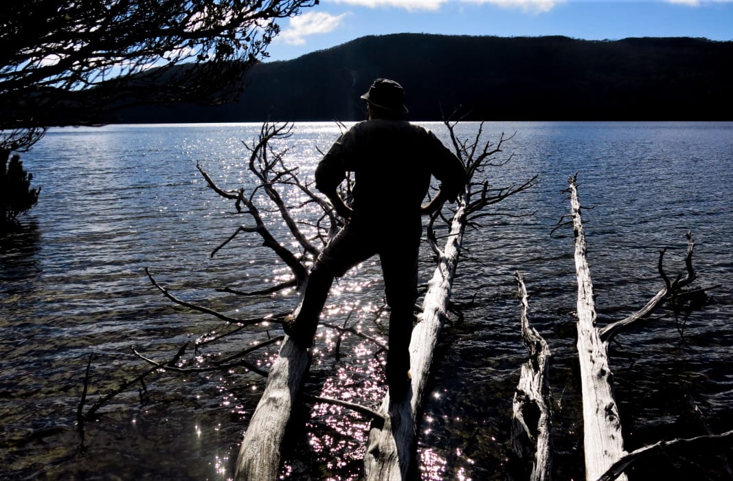
It also offers one of the most perfect natural camping spots in the state and – at no extra charge – provides a stunning view of the mountain most visitors are there to experience. It even has a conveniently fallen dead tree jutting into the shallows, affording the ideal spot from which to look back on a successful hiking expedition.
And it was here that we found ourselves mid-afternoon, warm sun on backs, cool water on bare feet and refreshing beverage in hand, reminiscing about the previous seven hours of exercise.

Knowing we would not be returning to civilisation and all its related complications until the following morning, it was an opportunity to enjoy a spell in glorious absence of mobile phone reception.
As the refreshments were consumed, the water seemed to grow more soothing, the view more stunning and the day more perfect.
With the sun dropping, Mount Rogoona loomed as a brooding presence across the water. Its name is derived from the Aboriginal word for forehead, the western edge of the peak looking like a bald bonce engaged in a staring competition with Cathedral Mountain and Bishop Peak.
It is moments such as this which have prompted an ever-growing band of adventurers to explore the Abels, Tasmania’s 158 mountains higher than 1,100 metres and with a drop of at least 150 metres on all sides, as defined by author Bill Wilkinson in his two-volume chronicle of the series.
This particular expedition took three days and involved two nights staying at this majestic camping spot. It is both flat and soft, cleared of excess vegetation by a bushfire in 1980, and comes complete with fresh water and yet – from our experience – apparently devoid of leeches.
It can be reached via Lake Bill past Nescient Peak (1,125m), but we had opted to park at the southern extremity of Mersey Forest Rd, walk in on Moses Creek Track and then follow a neglected but magical old trail initially running alongside the fast-flowing Jacksons Creek.
After traversing a suspension bridge shortly before Moses Creek, the track continues towards Chalice Lake, heading south-east. We discovered a series of delightful stone steps which must have taken considerable construction. Following cairns through a charred area heavily damaged by bushfires, we eventually crested a ridge to be confronted by a magnificent view of Rogoona due south, beckoning us towards its 1,350m splendour. A crystal-clear creek, bright red waratah and perfectly-placed pencil pines created ideal conditions for some healthy competition among our party photographers.
The extensive delights of Lake Myrtle are not far beyond this point.
After setting up camp to maximise enjoyment of surrounding sights and starlit skies, we dined in the plush surroundings. Fallen trees made for a quaint kitchen as resident songbirds provided the soothing background music. A solid night’s sleep preceded a day of weight-free adventure that made the surrounding pair of full-pack lugging worthwhile.
For maximum benefit, we had decided to combine scaling Rogoona with visiting Lake Meston and its historic hunting hut. Neither disappointed.
Lake Meston is one of those huge bodies of water which ensure Tasmanians should never have to want for our most precious natural resource. The hunting hut is equally beautiful, appearing out of the surrounding forest like the setting of a Hansel and Gretel fairytale, albeit with fewer witches and more mosquitoes.
Built in 1970 by Dick Reed, then in his 70s, it is a splendid combination of pencil pine beams, palings, slabs and shingles. There are four bunk beds, three small windows, a split stable door and a large tin chimney, all lovingly protected by Tasmania’s priceless Mountain Hut Preservation Society.
Like the nearby Junction Lake Hut, it was designed by Reed’s regular collaborator Reg Hall who was also responsible for several ski lodges on Ben Lomond plus the hut on the self-named Halls Island in nearby Lake Malbena, the site of a controversial helicopter-accessed tourism development proposal.
Returning north, we utilised both marked routes to reach Rogoona’s summit and return to Lake Myrtle, although the abundance of stone cairns across the mountain’s higher reaches made for much meandering and even more hearty debate about the preferred way ahead.
The positive side-effect of all this meant exploring numerous photogenic tarns, each encircled with flowering scoparia and more dead pencil pines. Wilkinson also suggests these tarns as an alternative camping spot. The surprise discovery of a half-built rock shelter in a place which would have an intimate relationship with the word windswept added intrigue to our adventure.
Another bonus was adding to our agenda a false summit slightly lower than, and 1km away from, the recognised peak but affording superior lake views plus the companionship of an inquisitive wedge-tailed eagle keen to check out these strange humanoids encroaching on its domain.

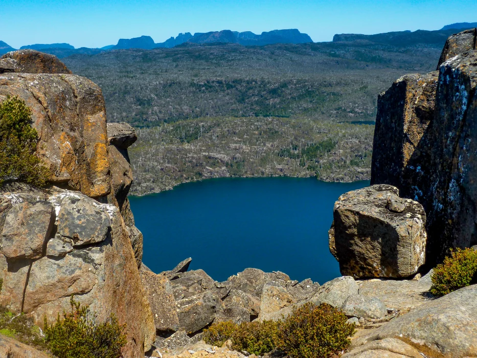
The close proximity of our bed for the night afforded an extended pause at the summit cairn to enjoy the seemingly endless Abels on view from both neighbouring national parks plus the nearby Great Western Tiers.
The western horizon is sublime – an almost unbroken line of jagged peaks filling the panorama like the jaw of a shark with bad dental history.
Returning to mobile reception meant firing up the Peak Finder app which revealed that more distant mountains as far afield as the West Coast, Lyell Highway, Ben Lomond plateau and far north-west were also on offer.
Wilkinson states that Rogoona (which was known as Jorgensens Peak by Reed) can be conquered as a day trip estimated at nine hours. But that would sacrifice the pleasures of relaxing at Lake Myrtle. Do yourself a favour, wake up and smell the eucalypts.
More in the ABELS series:
- Nescient Peak
- Black Bluff
- Mensa Moor
- Mount Ironstone
- Clumner Bluff
- Frenchmans Cap
- Drys Bluff
- Mount Murchison, Mount Dundas
- Mersey Crag and Turrana Bluff
- Clear Hill and Mount Wedge
- Parson and Clerk
After 13 years as a journalist in his native England, Rob Shaw moved to Tasmania with his young family in 2002. He has since continued to write about sport, covering two Olympic Games, three Commonwealth Games and many other major events, while also exploring the Tasmanian wilderness. His book, Shaw Things, is a compilation of some of his best newspaper columns. It was published by Forty South Publishing.